
The 25 Best Accessible Trails in America
We talked to the experts about everything from surface stability to parking to find the most epic trails in the U.S.
New perk: Easily find new routes and hidden gems, upcoming running events, and more near you. Your weekly Local Running Newsletter has everything you need to lace up! .
There’s stiff competition to get onto any “best of” trail list in the United States. But with sweeping views of towering rock features, ruins of historic railroad towns, and some of the biggest trees in the world, these trails are all bucket-list worthy on their own merits. Unlike the other lists, however, this one takes surface stability, cross slope, accessible parking, and trail grade into account. I first��interviewed experts like creator Cecilia Travis��and �ڴdzܲԻ�����Syren Nagakyrie, as well as wheelchair adventurers from across the country, including��, ,��and “4WheelBob” Coomber. Then��I scoured dozens of national-park accessibility guides and whittled down a massive list to bring you 25 trails that each offer a unique slice of American wilderness.
South Rim Trail
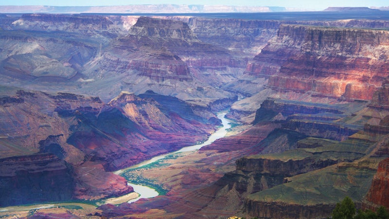
Grand Canyon National Park, Arizona
Distance: 13 miles;��point-to-point
Trail surface: Paved and packed gravel
Beginning at the South Kaibab Trailhead and ending at the stone ruins of Hermits Rest, this path cuts right along the rust-colored cliff��edge��of the Grand Canyon. Though much of the trail is unpaved, it presents few obstacles for those in wheelchairs and has a negligible elevation profile. Start at the accessible, 1.3-mile Trail of Time to learn about the unique geology of the area via interpretive signs and rock samples, then continue along the paved trail to South Kaibab before hopping onto a wheelchair-friendly shuttle bus to Hermits Rest for a three-mile��paved trek full of those famous��panoramic canyon views. Those looking to go the full 13 miles might want to bring a friend along for the unpaved section of trail between Monument Creek Vista and Bright Angel Lodge.
Lower Yosemite Fall Loop
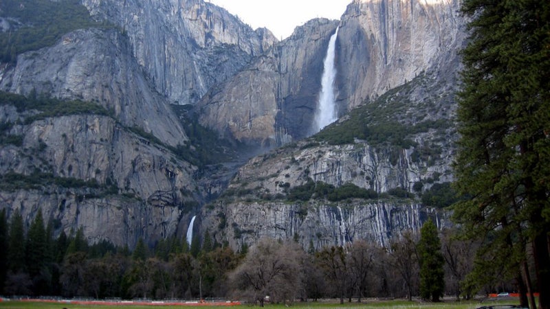
Yosemite National Park, California
Distance: 1.1 miles; loop
Trail surface: Paved
Feel the spray of mist and hear the roaring power of the famous waterfall up close on this paved loop trail leading to the base of .��Along the way are seating areas and boulders set at wheelchair height, orientation maps, and tactile, educational exhibits that lend a sense of scale to the grandeur that is . An accessible restroom and picnic area can be found at the trailhead. (Worth noting:��the last half mile��of the trail has a brief section with a��13.8 percent��grade.)
Shark Valley Tram Road Loop
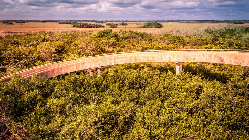
Everglades National Park, Florida
Distance: 15 miles; loop
Trail surface: Paved and wooden boardwalk
This paved, multi-use trail is rife with opportunities to see wildlife. Visitors here have spotted herons, egrets, snail kites, deer, and, yes, even the �����������������’ most notorious resident, the alligator. Veer slightly off the tram loop behind the visitor center��and onto the Bobcat Boardwalk for a closer look at the sawgrass slough and tropical-hardwood forest. ��can pick you up when you’ve had enough��and is��accessible with advance notice.
Bear Lake Loop
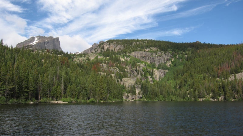
Rocky Mountain National Park, Colorado
Distance:��0.6 mile; loop
Trail surface: Hard-packed dirt
Set at an elevation of 9,475 feet, the Bear Lake Loop winds through a dense forest of spruce and fir trees��situated at the base of Hallett Peak and Flattop Mountain. Some may find this high-altitude dirt trail to be challenging, due to its 95 feet of elevation gain, but the impressive views of wooded hillsides and notorious fourteener��Longs Peak will more than make up for any breathlessness. Hike counterclockwise to follow along with an interpretive guide that can be purchased at the trailhead ($2).
Big Trees Trail
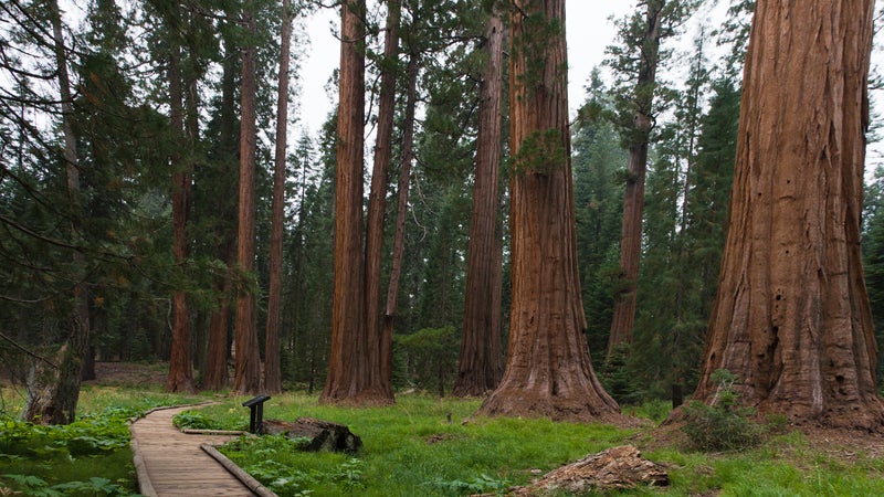
Sequoia National Park, California
Distance:��0.8 mile; loop
Trail surface: Paved and wooden boardwalk
Giant trees tower over��visitors��on this loop trail in the heart of Sequoia National Park. From the accessible parking lot, take a gently graded dirt trail to the Giant Forest Museum (free with park admission) to jump-start your tree knowledge. Continue��onto the mostly paved loop that curves through massive, thousand-year-old sequoias before traversing the lush, green grasses of Round Meadow.
Pa’rus Trail
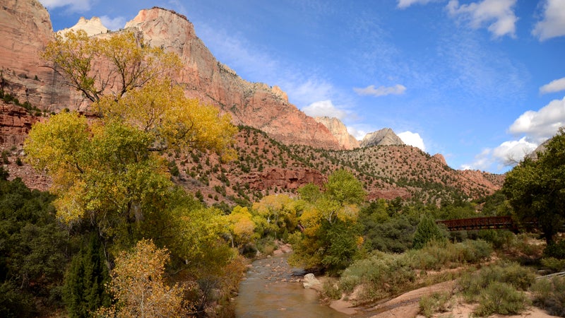
Zion National Park, Utah
Distance: 3 miles; out-and-back
Trail surface: Paved
Zion is famous for its crimson��and ocher-colored sandstone cliffs, and the Pa’rus Trail meanders right through some of the best sights. This paved, eight-foot-wide multi-use trail starts at the Zion Canyon Visitor Center and hugs the serpentine curves of the Virgin River before ending at Canyon Junction. A brief section of trail has a steeper, 18 percent��grade. You then��have the option of turning around at Canyon Junction for a three-mile round-trip or taking a wheelchair-accessible shuttle bus back to the trailhead.
Bar Island Sand Bar
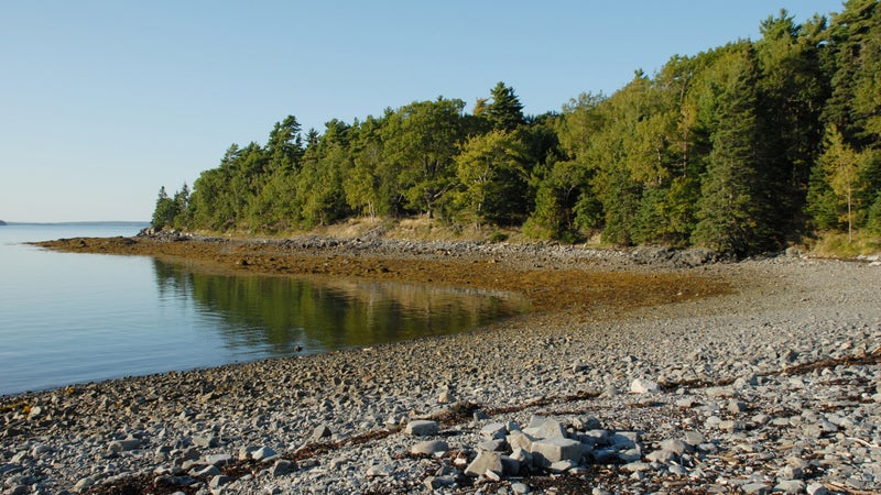
Acadia National Park, Maine
Distance: 0.08 mile; out-and-back
Trail surface: Sand
OK, so you’ll need knobby tires, a FreeWheel, and a friend to explore this ephemeral trail that’s only reachable for three hours a day at low tide, but writer and self-described wheelchair-travel addict Peter Littrell says that’s half the fun. Use a ��to find a safe time to explore the area. “It’s pretty sweet wheeling over the dried ocean floor to a forested island,” Littrell says. “Soak up the views of the Maine coastline as the wind rips in over the dark blue Atlantic.”
Boardwalk Loop Trail
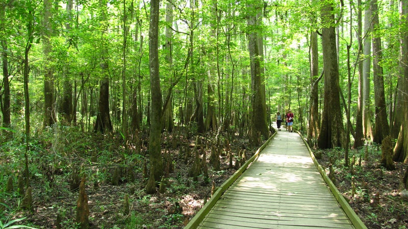
Congaree National Park, South Carolina
Distance: 2.4 miles; loop
Trail surface: Wooden boardwalk
Congaree National Park boasts the largest tract of old-growth bottomland hardwood forest in North America (try saying that three times fast), and the Boardwalk Loop Trail is designed specifically to give visitors a firsthand look at the majestic beech, oak, and bald cypress trees that thrive there. Pick up a self-guided brochure at the Harry Hampton Visitor Center, then spend the day admiring the dense forest and learning about its history as you listen to the same sounds of songbirds, frogs, and insects that the Congaree and Catawba tribes heard centuries ago.
Devils Garden to Landscape Arch
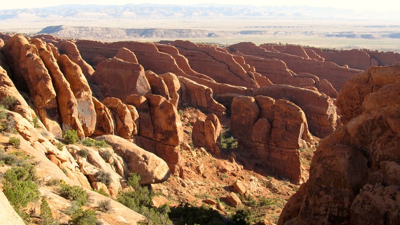
Arches National Park, Utah
Distance: 1.6 miles; out-and-back
Trail surface: Hard-packed dirt and sand
Standing at an impressive 306 feet long, Landscape Arch is the largest in North America. This relatively level trail begins at the Devils Garden Trailhead, at the far end of the road leading into Arches National Park. Wheelchair hikers may require some assistance on a few steeper sections. Visitors here can scan the horizon for other well-known rock features, like the Pine Tree, Tunnel, and Wall Arches, as they navigate towering sandstone fins on the way to the trail’s grand finale, Landscape Arch.
Great Sand Dunes National Park
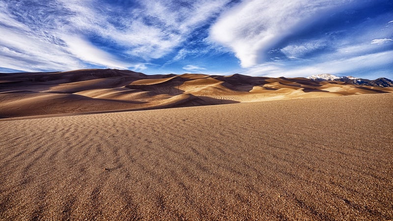
Colorado
Distance: N/A
Trail surface: Sand
Though not technically a trail, Great Sand Dunes National Park has many fantastic and accessible ways for visitors to explore the tallest sand dunes on the continent. Guests can get off the beaten path by borrowing a sand-friendly wheelchair with inflatable tires from the visitor center (free with admission; reserve ahead in summer) and having an intrepid buddy lead them around the Medano Creek area and onto the dunes for an afternoon. At night, check out a ranger-led wildlife and astronomy program at the accessible, open-air amphitheater.
Swiftcurrent Nature Trail
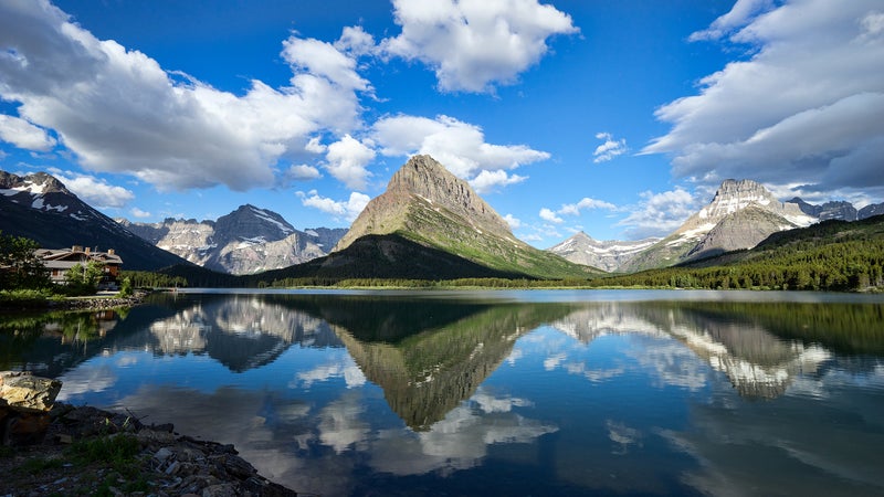
Glacier National Park, Montana
Distance: 1.5 miles;��out-and-back
Trail surface: Packed gravel
Soak up some of the best views of Allen Mountain, Grinnell Point, and Swiftcurrent Lake on this mostly level path that begins at the Grinnell Glacier Trailhead. Traverse a lakeshore forest of lodgepole pine and subalpine fir, and scan the lower slopes of Altyn Peak��near the for moose, grizzlies, and bighorn sheep. Construction is underway to make the entire loop wheelchair friendly by 2025,��but for now, some assistance may be needed after the first 0.75 miles, due to uneven terrain.
Upper Geyser Basin Trail
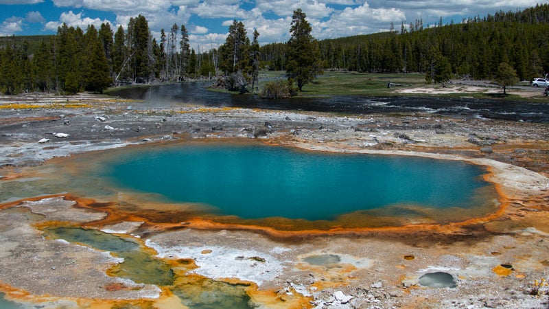
Yellowstone National Park, Wyoming
Distance: 2.8 miles;��out-and-back
Trail surface: Paved and wooden boardwalk
No trip to Yellowstone��would be complete without a hike along the boardwalk to watch Old Faithful erupt. Find an accessible parking spot at the , then spend the day exploring the��multi-use trail up to the brilliantly colored Morning Glory Pool, catching glimpses of Castle, Daisy, and Riverside Geysers along the way. Download the phone app for up-to-the-minute eruption predictions, and end your journey by watching the powerful spray of Old Faithful as the sun sets beyond the basin.
Badwater Basin Salt Flats
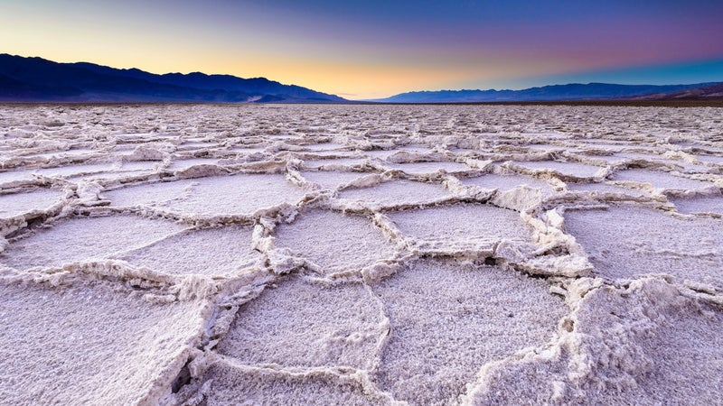
Death Valley National Park, California
Distance: 1-plus��miles; out-and-back
Trail surface: Wooden boardwalk and hard-packed salt flats
At 282 feet below sea level, Badwater Basin is the lowest point in North America. This arid expanse of salt and mineral deposits is almost perfectly flat, and an accessible boardwalk puts hikers right onto the edge of the 200-square-mile tract. “If the season is right, and you’re prepared with knobby tires and a FreeWheel, keep pushing right onto the crunchy, white salt flats, where the hottest temperatures in the world evaporate all the water that drains here,” says Littrell.
Window View Trail
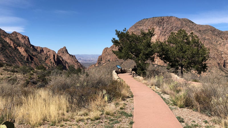
Big Bend National Park, Texas
Distance: 0.3 mile; loop
Trail surface: Paved
Not to be confused with its neighbor, the much longer Window Trail, the Window View Trail is a perfect slice of some of the best scenery in Big Bend National Park. Beginning at the Chisos Basin Trailhead, this paved path serves up some seriously amazing views of high-mountain peaks and craggy rock formations. Hit the trail when the sun gets low to enjoy a classic Big Bend sunset, watching the light paint neighboring rocks in striking shades of coral, amber, and rose.
Yosemite Valley Floor Trail
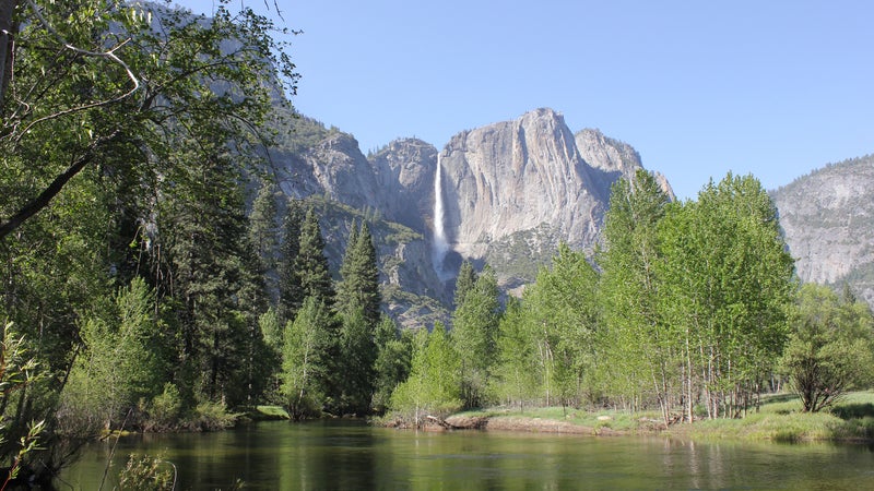
Yosemite National Park, California
Distance: 12 miles; loop
Trail surface: Paved
Wind along the blue ribbon of the Merced River, crane your neck to take in the majesty of Royal Arches, and nab that perfect picture of Half Dome on this paved multi-use trail, which��snakes around the highlights of Yosemite Valley. “It’s like rolling in a postcard,” says Bob Coomber. Nearly all 12 miles of this pathway are accessible, apart from a few steps at the Superintendent’s Bridge and a short, steep section near Housekeeping Camp.
Sunrise to Sunset Point
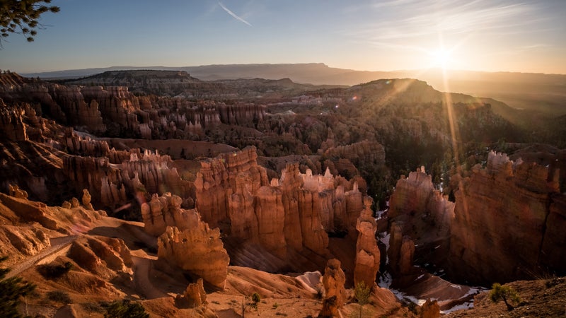
Bryce Canyon National Park, Utah
Distance: 1 mile;��out-and-back
Trail surface: Paved
Rise early to beat the crowds and catch the sunrise on this short trail, which��offers up some of Bryce Canyon’s best scenery. Beginning at either Sunrise or Sunset Point, hikers here can gaze out at the panoramic view of Queen’s Garden, Wall Street, and plenty of rust- and umber-colored hoodoos and rock fins. This high-altitude trail sits at 8,000 feet above sea level and features accessible parking and several seating areas to rest and admire the immense canyon below.
McKinley Station Trail
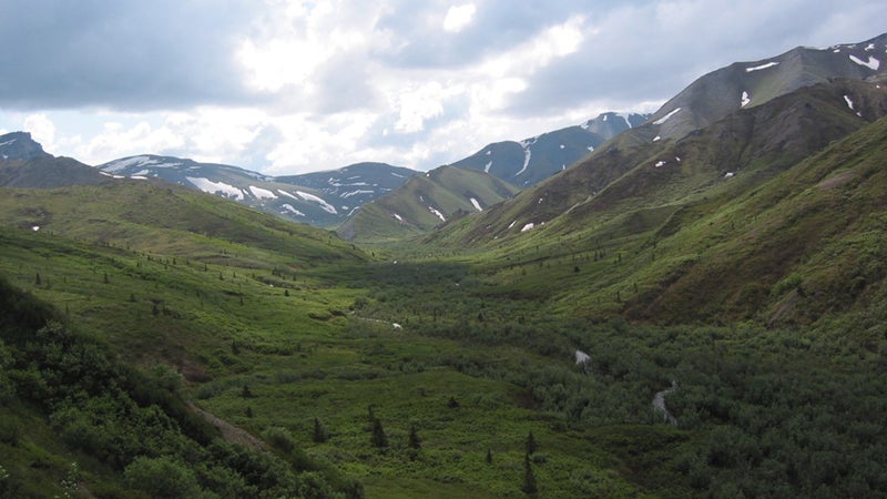
Denali National Park, Alaska
Distance: 3 miles; loop
Trail surface: Packed gravel
Travel back in time to an era when fur trappers, gold prospectors, and hunters roamed the vast Alaskan wilderness��on this gently graded, 1.6-mile trail that connects with the Denali Bike Trail to create a three-mile loop. Pick up a hiking guide at the Denali Visitor Center for an in-depth look at the area’s history. Then wind through a picturesque forest full of spruce and quaking aspen, gaze up at the historic Alaska Railroad Trestle, and saunter along the banks of Hines and Riley streams.
Redwood Grove Loop Trail
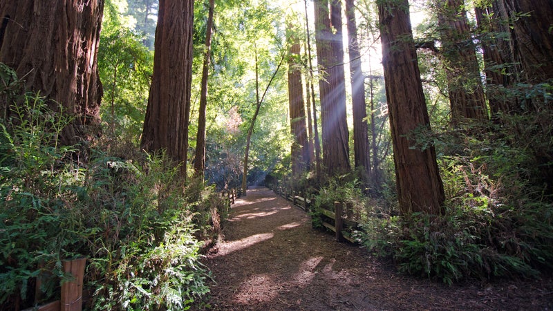
Henry Cowell Redwoods State Park, California
Distance:��0.8 mile; loop
Trail surface: Hard-packed dirt
The Redwood Grove Loop Trail offers hikers the chance to experience the rich quality��of Santa Cruz’s only remaining old-growth grove. As visitors amble around this 0.8-mile loop, they’ll be greeted with a characteristic hush—ground plants like redwood sorrel and ferns dampen nearby city sounds. The park also offers several ��(from $35) for overnight adventurers. “This is the type of trail where you want to take your time and breathe in the full experience of being surrounded by the beauty of a redwood forest,” says Irishsea.
Coyote Valley Trail
Rocky Mountain National Park, Colorado
Distance: 1 mile; out-and-back
Trail surface: Packed gravel
Set at an altitude of 8,840 feet, this mostly level trail crosses the mighty Colorado River and allows visitors to explore the expansive Kawuneeche Valley. Named after the Arapaho word for “coyote,” the valley provides incredible views of the Never Summer Mountains and the western slopes of the Continental Divide. Keep your eyes peeled for bursts of alpine wildflowers, elusive moose, and the valley’s namesake coyote.
North Pathway to Jenny Lake
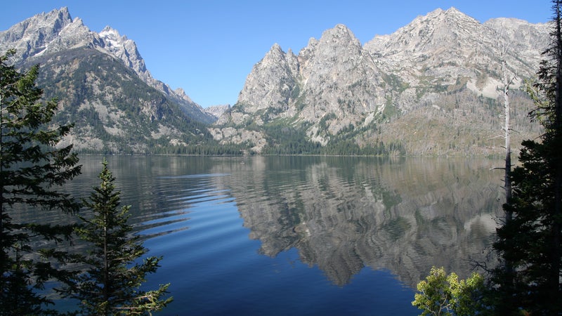
Jackson, Wyoming
Distance: 20.3 miles; point-to-point
Trail surface: Paved
Though the accessible trails within Grand Teton National Park are short and rugged, the town of Jackson is home to a wealth of multi-use pathways that allow visitors to soak up all the splendor of the Tetons and push bigger miles. By far��the most impressive of the bunch is the 20.3-mile route that parallels the highway from central Jackson to Jenny Lake. Pass��through an elk refuge, visit the National Museum of Wildlife Art, cross the Snake River, and look up��to catch that perfect view of the Grand.
Kestner Homestead and Maple Glade Loop
Olympic National Park, Washington
Distance: 1.5 miles; loop
Trail surface: Hard-packed dirt
Fall in love with the emerald lushness of Olympic’s old-growth temperate rainforest on this dirt trail, which��leads��to a historic homestead. Beginning at the Quinault Rain Forest Ranger Station, the path may require slight assistance as it cuts��through moss-draped maples, head-high sword ferns, and flowering skunk cabbage before intersecting with the beautiful and fully accessible Maple Glade Nature Loop. “With a fern-covered cliff rising to the right��and a moss-covered fence to the left, green is exploding everywhere—even the moss is covered in moss,” says Littrell.
Devastation Trail
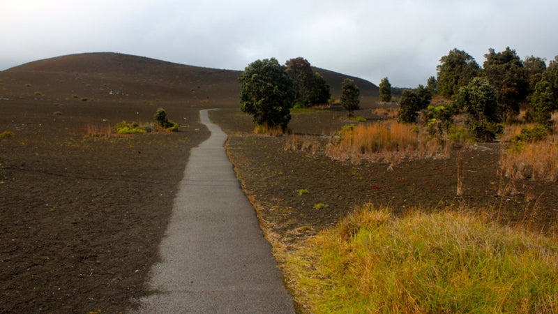
Hawaii Volcanoes National Park, Hawaii
Distance: 1 mile;��out-and-back
Trail surface: Paved
Though not as flamboyantly scenic as many of the trails on this��list, this route through Volcanoes National Park offers a rare and starkly beautiful look at a landscape in recovery after the 1959 Kilauea Iki eruption. Once buried by falling cinder, this fragile ecosystem is making a comeback, and endangered Hawaiian nene��are often spotted here. The highlight of the trail is the Puu Puai Overlook, where hikers can get a more panoramic view of how this volcanic spatter cone was formed.
Riverside Walk
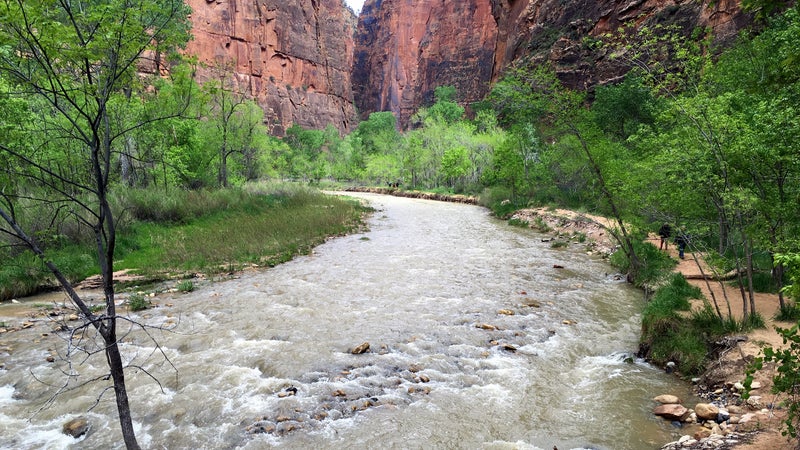
Zion National Park, Utah
Distance: 2 miles; out-and-back
Trail surface: Paved
Starting at the last shuttle stop, Temple of Sinawava, hikers can traverse verdant��hanging gardens, huge waterfalls, and weeping sandstone walls as they saunter through��Zion Canyon. Look for mule deer and blue herons on this trek, once known as the Gateway to the Narrows.��At the 0.4-mile mark, the trail tapers and briefly exceeds a grade of 20 percent, so having a friend tag along is recommended for those looking to go the full two��miles.
Sugarlands Valley Nature Trail
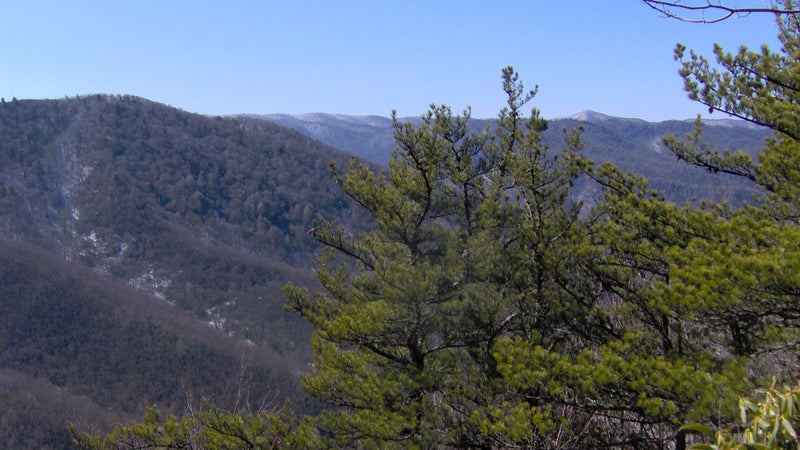
Great Smoky Mountains National Park, Tennessee
Distance:��0.5 mile; loop
Trail surface: Paved and wooden boardwalk
As the only accessible trail in the nation’s most visited national park, Sugarlands Valley Nature Trail has a lot to live up to. Though it boasts no panoramic views, it does offer a more intimate look at east Tenessee’s famous mountain range. Deer, black bears, and wild turkeys frequent the area, and the trail passes by��the remains of the historic Sugarlands settlement, which predated the national park. Those lucky enough to visit in the fall will glimpse a special treat when the leaves of the surrounding forest turn electric shades of red, yellow, and orange.
Godfrey Glen Loop Trail
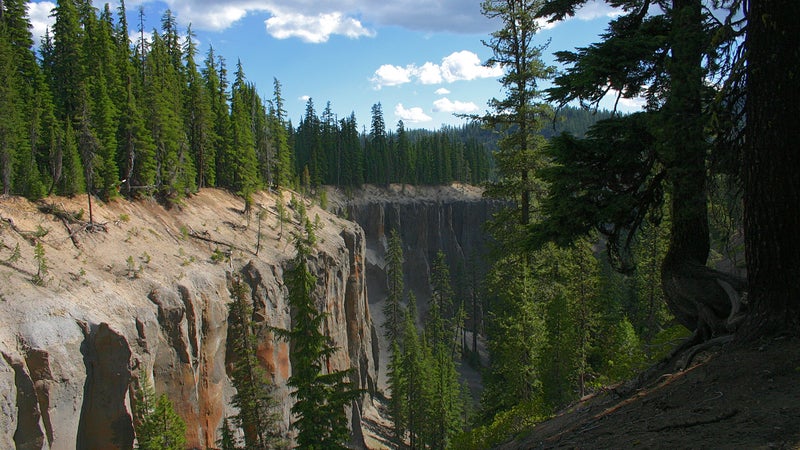
Crater Lake National Park, Oregon
Distance: 1 mile; loop
Trail surface: Hard-packed dirt
Sure, Crater Lake is known for epic views of its namesake sapphire tarn, and many viewpoints along the rim are accessible. But��for those looking to venture a little farther out from their car, the Godfrey Glen Trail is a perfect afternoon adventure. This dirt pathway starts at Munson Valley Road and meanders��through an old-growth forest full of Shasta red firs. The trek features some breathtaking views of the crumbling volcanic cliffs above Munson Creek and Annie Creek Canyon’s distinct, columnar formations. In spring, be on the lookout for wildflower rarities, like the bell-shaped blooms of the pinedrop.