


Unlike most��parts of the country, where recreational activities are dictated by the thermometer, in Los Angeles,��there is no such seasonal limitation. Thus,��it��should come as no��surprise��that the place whose climate renders it SUP-able in February is, at times,��the subject of every��outdoor athlete’s envy.
But being endowed with divine control over your active lifestyle destiny poses the challenge of coming to terms with the wealth of choice: Is your Saturday morning better spent exploring the trail-running options in Griffith Park, mountain biking��the virtually endless trails of the San Gabriel Mountains,��planting��your toes on holds that have been touched by Royal Robins, or perhaps��yielding to a repressed desire to go rollerblading along the Pacific? Unfortunately, our Active Cities guide won’t make that decision��any easier, but hopefully it stokes your fire and inspires you to escape the gridlock traffic this weekend.
Best Runs
Ah, Los Angeles: the city whose year-round mild weather makes it the meteorological envy of so many harsh East Coast climes is also a runner’s paradise. From ocean-front boardwalks to secluded trails beneath Ponderosa pines, L.A. caters to every kind of runner. In a city with near limitless options for clicking off the miles, here are some of the best.
—Martin Fritz Huber
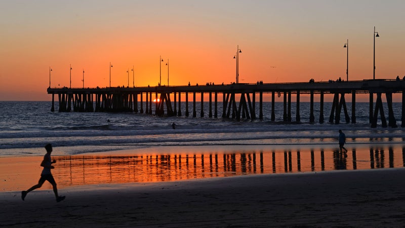
Santa Monica to Venice (and Back)
Distance: 5 miles
Type of run: Paved path
For: Scene seekers
It’s roughly 2.5 miles from Santa Monica to the heart of Venice Beach along what might be the most widely of Southern California beachfront property. This short portion of the larger 22-mile bike path, known locally as the Strand, has a pedestrian walkway and will delight anyone who wants a taste of the bustling, iconic scene surrounding the world-famous Santa Monica Pier. If you’re planning to do some of the touristy things anyway—like checking out the Ferris wheel and the aspiring Arnolds at Muscle Beach—what better way than while on a run?
Palisades Park: Santa Monica Pier Loop
Distance: 3 miles
Type of run: Packed-dirt trail—and stairs
For: Stair masters
For an elevated perspective on Santa Monica State Beach, Palisades Park on Ocean Avenue is a narrow, 26-acre strip of park that offers killer views of the Santa Monica Pier and the Pacific Ocean. The park’s dirt path runs roughly 1.5 miles from end to end. Runners can behold towering palms, sunsets, spry celebs, and tai chi enthusiasts. If you don’t mind incorporating steep stairs into your run, you can extend it by descending from the bluffs to the beach bike path.
Hermosa Valley Greenbelt
Distance: 3.5 miles
Type of run: Wood-chip path
For: Joggers who want to take it easy on the joints
Once upon a time, railroad tracks ran along this stretch between the southwestern Los Angeles cities of Manhattan Beach and Redondo Beach. These days, there is a path officially called Veterans Parkway (but known to locals as the Greenbelt), flanked by lush SoCal flora. The trail is about 3.5 miles long and only a quarter-mile inland from the beach, so runs can begin (or, more likely, end) with a quick dip in the ocean—not that you’d necessarily want to stray from this gorgeous path, which includes exercise stations and mile markers.
Runyon Canyon Park Trail
Distance: 2.5 miles
Type of run: Dirt trail
For: Celebrity stalkers
What’s a trip to L.A. without a run in the Hollywood Hills? Besides the prospect of spotting celebrities in their workout clothes, one of the great pleasures of Runyon Canyon is that much of it is also a dog park. (Because who can resist celebrity dogs?) Be advised: This “urban wilderness,” as the L.A. Department of Parks and Recreation deems it, is a popular spot. Runyon Canyon Park is not the place to go if you want a solitary running experience. What the park might lack in tranquility, however, it more than makes up for in scenery, with awesome views of the L.A. skyline and local landmarks like, yes, the Hollywood sign.��
Silver Lake Reservoir
Distance: 2.2 miles
Type of run: Dirt loop
For: Runners with dogs
The Los Angeles equivalent to New York’s Central Park Reservoir is the Silver Lake Reservoir jogging trail. This 2.2-mile, mostly flat, mostly dirt path circumvents what was until recently an urban lake in the eponymously named neighborhood near central Los Angeles. Like its NYC counterpart, the Silver Lake Reservoir was taken offline many years ago. In 2015, it was drained for renovation purposes. At present, it still stands empty, much to the annoyance of many local residents who enjoyed cool breezes off the water on hot days. If they get their way, 2017 may see the reservoir refilled.
Lake Hollywood Reservoir
Distance: 3.4 miles
Type of run: Paved loop
For: Speedwork specialists��
If you prefer your reservoirs filled with water, a better option than Silver Lake (for now) is the loop circumventing man-made Lake Hollywood in the Hollywood Hills. This flat paved path runs just over three miles and is equally ideal for speedwork and tranquil evening jogs. Sorry, you can’t bring your dog.��
Griffith Park
Distance: 6.5 miles
Type of run: Dirt trail
For: Runners who want to get lost in the urban wild��
As if Angelenos weren’t spoiled enough when it comes to enviable running options, the city also boasts one of the largest urban parks in the country. With 53 miles of trails within 4,300 acres, it feels absurd to recommend just one running option in Griffith Park. That said, the 6.5-mile up to the Hollywood sign on Mount Lee is pretty great. Find the trailhead on off Canyon Drive just inside Griffith Park, and watch out for rattlesnakes.
Cooper Canyon Falls Loop, Angeles National Forest
Distance: 9 miles
Type of run: Forest trail
For: PCT samplers
Since thru-hiking the Pacific Crest Trail isn’t for everyone (or everyone’s employer/significant other), it’s a good thing many spectacular sections of the route can be incorporated into a day trip. It’s about a 90-minute drive inland from central Los Angeles to the Buckhorn Campground in Angeles National Forest, but the journey is more than worth it. From the Burkhart trailhead, hoof it out to Cooper Canyon Falls (about 1.5 miles). Circle back via the PCT and Cooper Canyon Trail Camp to take in the manifold glories of this stretch of western forest. Fair warning: This one isn’t for the faint of heart, or lung—the trail undulates between 5,500 and 6,500 feet.
Los Liones Trail
Distance: 7 miles
Type of run: Dirt trail
For: Hill-running champs
Save this one for a clear day—and one when you don’t mind tackling some significant elevation gain. The trailhead of Topanga State Park’s Los Liones Canyon Trail is off Los Liones Drive (across the street from an unmistakable Mormon church). From there, it’s seven miles round-trip to the 1,525-foot Parker Mesa Overlook. Those who brave the strenuous ascent are rewarded with killer views of the Pacific Coast from the summit—although the way up isn’t too bad either, especially if you make the trip when wildflowers are in bloom, usually in spring. And bring sunscreen—like much of Topanga, the terrain here is exposed to the sun. ��
The West Loop in Elysian Park
Distance: 2.4 miles
Type of run: Dirt trail
For: Trail runners who don’t want to leave the city
Founded in 1886, Elysian Park is the oldest park in the city and offers the unique experience of fine trail running in the immediate vicinity of downtown Los Angeles. The trailhead for the West Loop is at the intersection of Elysian Park Drive and Stadium Way. Be warned: Dodger Stadium sits in the center of the Elysian Park neighborhood, so those seeking peace and quiet should probably avoid game days, when the park gets more foot traffic and loses some of its quiet urban oasis vibe.
��
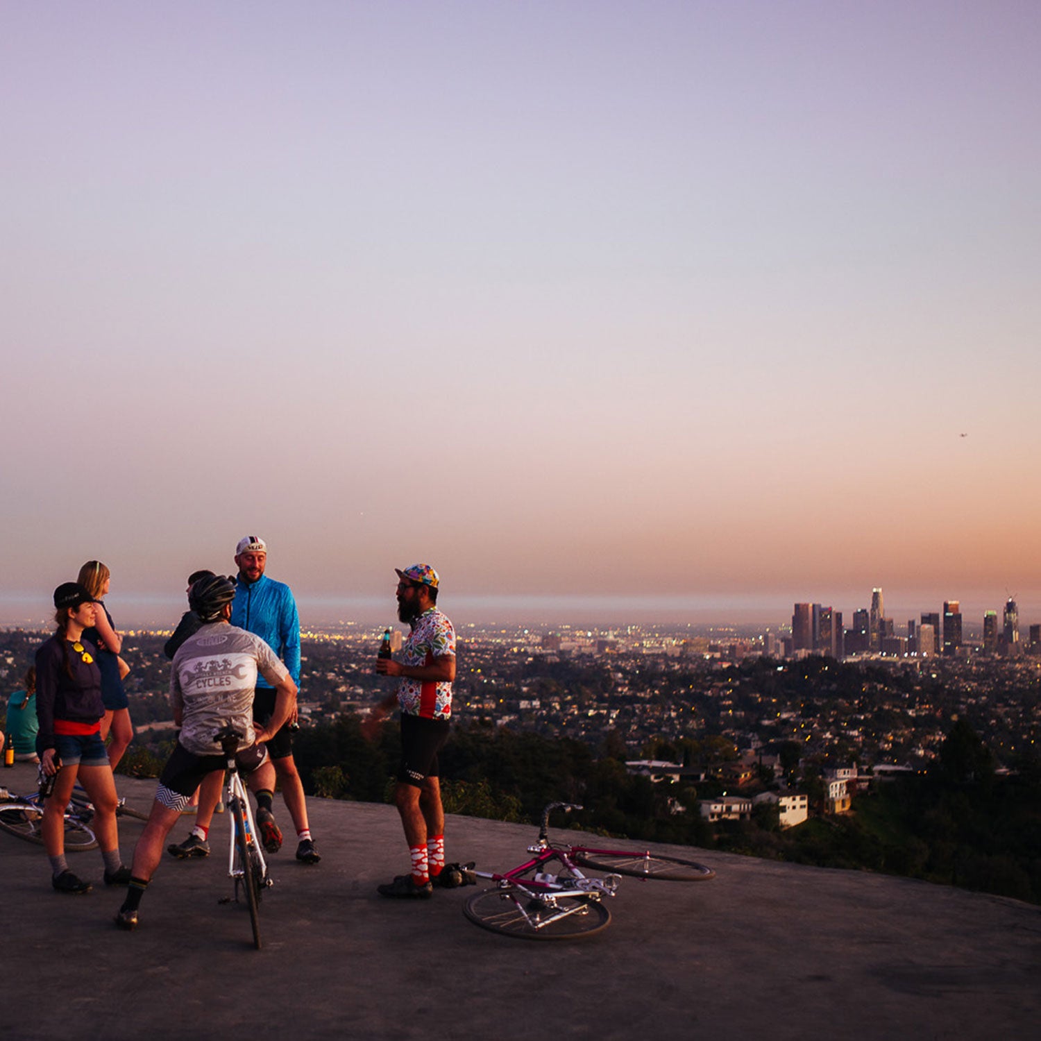
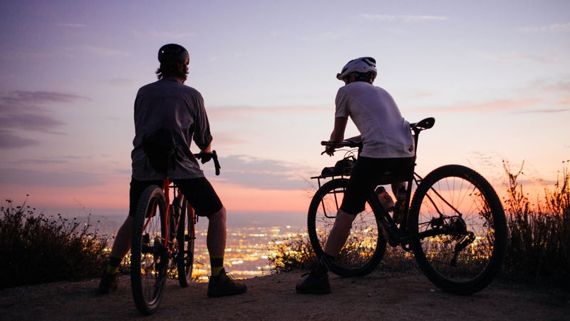
Best Rides
When it comes to cycling, L.A. gets a bad rep—and, frankly, between its sprawling size, the gridlock traffic, and the awful air quality, it’s pretty justified. But all you have to do is look to the neighboring San Gabriel Mountains and the Angeles National Forest to find some of the best riding—both mountain and road—in the country.
—John Watson
Verdugo Mountains
Distance: 20 to 30 miles��
Elevation gain: 2,800 to 4,000 feet
For: Dirt wizards
The spanish word verdugo roughly translates to “executioner,” which is a pretty good indication of the grades you’ll encounter in this small, rugged mountain range just north of the city. Enter the Verdugo Mountains via Mount Thom’s Las Flores Motorway to get a majority of the climbing over with. From there, ride the ridge of these deserted desert peaks along Verdugo Motorway, and take any number of dirt roads back down to Glendale. Pro tip: The earlier or later in the day you ride, the better, in terms of heat and wildlife sightings. Don’t be surprised to see foxes, weasels, bobcats, and even horned lizards scurry off the roads and into the brush.��
The 39��
Distance: 60 to 100 miles
Elevation gain: 6,000 to 10,000 feet
For: Dedicated climbers
With an elevation profile and switchback design that mirrors Italy’s famous Stelvio Pass, the 39, named after Highway 39, is one of the hardest climbs in the Los Angeles area. You’ll be sitting in the saddle for more than 20 miles as you climb and climb and climb some more. While you're in the pain cave, however, you won’t have to worry about cars: The upper portion of the 39 is closed to vehicles due to its hazardous road conditions. For a shorter ride, start at the beginning of Highway 39 in northeast L.A. and ride to Cogswell Dam, about 13 miles up the road. For a longer day, continue north all the way to Highway 2, which cuts across the San Gabriel Mountains. Either way, pack wisely: There’s likely no food or water until you reach Highway 2.
Cloud Burst
Distance: 75 miles
Elevation gain: 8,000 feet
For: Camera-wielding roadies
This route—which follows Highway 2, better known as Angeles Crest Highway, northeast into the Angeles National Forest—is not for the faint of heart. With 8,000 feet of total climbing, the route ends at the 7,018-foot summit of Cloud Burst Summit. Those looking for a true sufferfestcan continue to the end of Angeles Crest Highway, or you can simply turn around and enjoy the ride back down. We recommend filling up your bottles at Clear Creek or Red Box picnic area along the way. Pro tip: Stop by Newcomb’s Ranch, located six miles shy of the Cloud Burst Summit, and fill up on a burger and a beer before descending back down Highway 2.
Strawberry Peak
Distance: 16 miles
Elevation gain: 2,800 feet
For: Thrill seekers
As one of the true backcountry mountain bike loops in Los Angeles, Strawberry Peak is not for the faint of heart. You’ll be met with lots of exposure, forests of poodle dog bush, and even the occasional encounter with large animals, all of which make this loop one of the hardest yet most rewarding rides in the L.A. area.��
Park at the start of the Josephine Peak Road in Angeles National Forest. Follow Colby Canyon Trail around Strawberry Peak before you drop back down at Red Box picnic area via Strawberry Peak Trail. Add in the Switzer Trail for a bonus.
Griffith Helipad
Distance: 8 miles
Elevation gain: 800 feet
For: Cruisers
Also known as the “blacktop,” the Helipad is a large asphalt flat in Griffith Park that overlooks downtown L.A. and the Griffith Observatory. While this is certainly not the ride for a hard workout, the Helipad is a perfect spot to cruise on a single speed and watch the sunset. Afterward, you can sightsee through the rest of Griffith Park or simply go down the way you came up.��
In Los Feliz, take Commonwealth north and hang a right on Vista Del Valle Drive. You won’t be able to miss the Helipad.��
Mount Disappointment
Distance: 60 miles
Elevation gain: 6,500 feet
For: Mountain goats
Mount Disappointment—commonly known as Mount D—was named in 1894 when surveyors believed it to be the highest point in the area, until finding that San Gabriel Peak, half a mile east, is actually taller. Mount D is no easy feat—the last kicker up to the top will leave your legs burning for days—but it’s one of the most rewarding rides in L.A.
To get there, ride along Highway 2 up to Red Box and continue on Mount Wilson Red Box Road. Before long, Mount Disappointment Road will be on your right. Continue on that until you reach the summit. Ride it as an out-and-back or continue on to any number of other climbs in the area, including Mount Wilson to the southeast.
Brown Mountain to Ken Burton
Distance: 17 miles
Elevation gain: 4,000 feet
For: Switchback slayers
While this loop in the San Gabriel Mountains is quite popular, and thus can be heavily trafficked, its accessibility, moderate yet fun terrain, and abundance of spring wildflowers make this ride a must.
To get there, take Fern Truck Trail to Brown Mountain Road, and follow that to the start of the newly reopened Ken Burton Trail. Once you tackle the initial switchbacks, follow the wash west until you pick up the Gabrieleno Trail, which eventually leads out of the forest and down to the popular Windsor Avenue parking lot. If you prefer a rowdier descent back to your starting point, take Brown Mountain Road back down from Fern Truck Trail instead and descend on El Prieto. Watch out for hikers coming up the trail and the loads of poison oak.
Dirt Mulholland
Distance: 60 miles
Elevation gain: 6,000 feet
For: Dirt tourists
This ride makes clear the vast dichotomy that is riding in Los Angeles: a gorgeous dirt road bookended by urban sprawl. Head east on Mulholland Drive until the road turns to dirt—a part of the road appropriately referred to as “Dirt Mulholland.” From there, head south through Topanga State Park via any number of trials (best to consult a map). Be careful: It’s not unusual to see rattlesnakes, coyotes, and even a California condor here. From the bottom of Topanga, we recommend dropping down to the PCH, stopping by the Reel Inn for fish tacos, and completing the loop back to your starting point.
Lukens
Distance: 16 miles
Elevation gain: 5,000 feet
For: Altitude junkies
The highest point in the city of Los Angeles is the 5,066-foot Mount Lukens. Located off Highway 2, Mount Lukens Truck Trail is a steep, hard, good time. There are endless hairpin turns and long, rewarding climbs. It’s best to ride this road in the spring or winter, as summer temperatures can spike into triple digits here.��
This ride begins at the start of Mount Lukens Truck Trail, where you’ll find a ranger station with a spigot to fill your bottles or hydration pack. Once at the summit, either come back down the way you rode up or take any number of singletrack options down.��
Big Sycamore Canyon Trail
Distance: 20 to 30 miles
Elevation gain: 2,000 to 3,000 feet
For: Beach bums
The west side of Los Angeles has many great riding options in the nearby canyons, and while vehicular traffic can make many of these roads intimidating, finding dirt in the Santa Monica Mountains is always a rewarding experience. Ride along the PCH to Sycamore Canyon Campground and continue on Big Sycamore Canyon Trail. From the top, it’s a real looker, and you’re presented with dozens of options to drop back down to the coast.
Best Climbs
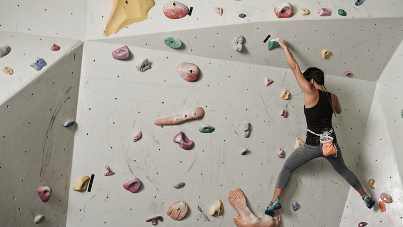
While L.A. is best known for its beach culture, it also has a vibrant climbing scene that’s home to some of the country’s most historic crags. It also boast an impressive gym culture where dirtbags and bronzed surfers who are bouldering for the first time can find common ground. Whether you're looking to��send Stonemaster classics or��simply want��an alternative to the gym, then L.A. climbing will treat you well.
—Alex Lubben
Touchstone Gyms
Type of climb: Boulder, top rope, sport
For: Downtown crushers
With locations in Hollywood, Downtown L.A., and Culver City, Touchstone Climbing has been a staple of West Coast indoor climbing since its inception in 1994. Its , called Cliffs of Id, has��a roped area that boasts 16,000 square feet of climbing on 40-foot walls. At Hollywood Boulders, you’ll find a welcome respite from the surrounding snooty culture in a gym full of like-minded climbers.��
A day pass will run you $20 during peak hours (weekdays after 3 p.m. and weekends). It’s $15 all other times, and memberships are $77 per month.��
Sender One
Type of climb: Boulder, top rope, sport
For: Orange County climbers
The Chris Sharma–designed ��near LAX��is a slick, top-tier climbing gym—what you’d expect from a space put together by one of the best sport climbers in the world. With 60-foot walls in a 30,000-square-foot space, it's one of the very few gyms to include a speed wall. Its��first location, in��Santa Ana, has a kids’ climbing zone, called Sender City, that's geared toward getting the young ones roped in early but also offers lower-commitment climbing to those who have some trepidation toward the sport.
A day pass costs $22. Memberships are $84 per month or $949 annually.��
The Stronghold Climbing Gym
Type of climb: Boulder, top rope, sport
For: Gym rats who are tired of bouldering
Housed in the remains of an old California Edison steam power plant, has 45-foot walls and is a go-to destination for indoor roped climbing in Southern California. Just east of the L.A. River from Chinatown, it’s pretty centrally located, too. Parts of both the roped and bouldering sections are reset weekly, and the entire gym gets a makeover no less than every eight weeks. Plus, the regulars here are eager to get outside—members bump into each other climbing at the local crags all the time. Bring your dog: Stronghold is pet friendly.��
Day passes are $20. Gear (including a chalk bag) is an extra $6. Memberships are $79 per month.��
Stoney Point Park��
Type of climb: Boulder
For: After-work boulderers
This bouldering area just 15 miles northwest of the Hollywood sign is a . Sierra Club members were perfecting their roped climbing techniques on Boulder 1 in the 1930s. It’s where Yvon Chouinard and Royal Robbins prepared for their big-wall first ascents in the ’50s. John Bachar honed his free-solo chops here in the ’70s. And it’s right off the freeway: You can park, walk just a few minutes, and hit your first highball—all without putting on approach shoes.
The Tramway
Type of climb: Boulder
For: Summertime boulderers
Head 100 miles east on I-10, hop on the (the world’s largest rotating tram), and you’ll be treated to a bunch of steep granite boulders underneath Mount San Jacinto, the second-highest peak in Southern California. It’s a little more out of the way than Stoney Point, and a round-trip tram ticket costs $25.95, so you’ll find fewer climbers here. If you’re looking for V6 and up, this is the place for you. Plus, the altitude keeps temperatures cool in the hot summer months.
Corona Del Mar
Type of climb: Bouldering
For: Beach-bum climbers
While you’ll want to bring a crash pad if you plan on hitting the classic 20-foot highballs at this old Stonemaster hangout, the soft sand at his beachfront bouldering spot provides enough of a cushion for some of the fun, shorter climbs. And when we say beachfront, we’re not kidding: Gulls squawk overhead and waves crash behind you as you climb the juggy sandstone. Be careful, though—on some routes, the holds are sure to be covered in sand, and the holds can be slick after rainy or foggy days.
Malibu Creek State Park
Type of climb: Sport, trad
For: Sport-climbing day-trippers
Scramble past the non-climbing crowds around the Rock Pool at Malibu Creek to gain access to more than 100 sport routes, with grades ranging from 5.8 to 5.14. Juggy limestone pockets are the staple here, but if you’re not up for leading just yet, the Planet of the Apes wall has you covered with a variety of intermediate-level top-rope routes. But be warned: At just a 45-minute drive west from most places in L.A., this spot can get quite crowded.
Saddle Peak
Type of climb: Trad, sport
For: The trad-curious
Located in the crest of the Santa Monica Mountains west of L.A., Saddle Peak is known for its “corpse wall”—local climbers discovered a dead body at its base. (There’s even commemorating the poor guy.) But not to fear, Saddle Peak also has some top-notch, lower-commitment slab climbing. Having some trad gear isn’t a bad idea here, as the 15 bolted sport routes are fairly run out. This spot isn’t as exposed as some of the other nearby trad-climbing areas, making it a great place to become more comfortable placing gear or climbing high above your last clip.
Joshua Tree
Type of climb: Trad, sport, bouldering
For: Weekend warriors
The two-hour drive east to Joshua Tree means you won’t be making a quick jaunt out here after work, but for world-class climbing in an area steeped in history, the travel time is a small price to pay. While the national park has more than 7,500 routes, it is perhaps best known for its classic multipitch trad climbs. You’ll also find plenty of hard bouldering here, as well as some top rope and sport climbs. If you do choose to spend the night, check out .
Holcomb Valley Pinnacles
Type of climb: Sport, boulder, trad
For: Sport-climbing aficionados
In terms of access, travel time, climate, and quality of rock and routes, Holcomb Valley is hard to beat. Up in the San Bernardino Valley, just north of Bear Lake, Holcomb offers a huge variety of moderate-level climbs. (Mountain Project calls it the area’s “.”) There’s a small bouldering area and about a hundred trad routes, but the real draw here are the 300 sport climbs at or below a 5.10 grade, all on Holcomb’s high-quality granite.��
Tahquitz and Suicide Rocks
Type of climb: Trad
For: Trad enthusiasts
Another Royal Robbins haunt, Tahquitz and Suicide Rocks—across the valley from each other in Idyllwild—are the premiere crags for traditional climbing in the L.A. area. The steep granite faces are exposed, and the few bolted sport routes here aren’t for the faint of heart—expect big runouts unless you place additional gear. Located 100 miles east of the city just south of Mount San Jacinto, it’s a bit of trek, but if you’re itching to be 800 feet off the deck on a seven-pitch route, this is the place for you.
Best Places to Refuel
Los Angeles is a diverse city, and that’s reflected in its food. You can finish your ride by slurping salty ramen until you’re rehydrated, or hop off your surfboard and crush a baby-sized burrito—and chances are you won’t have to travel far to find exactly what you’re looking for. Here are our favorite eats in a city that has many.
—AC Shilton

Pedaler’s Fork
This bike shop/bar/coffee shop/restaurant is the kind of place where you’ll only get slightly teased if you forget to take off your helmet before ordering a beer. Many cyclists frequent Pedaler’s Fork after a long ride in the Malibu hills. Peter Flax, Bicycling’s former editor in chief and current editor at the Hollywood Reporter, recommends the chicken and waffles, which he describes as “a cinder block through the glycogen window.”��
23504 Calabasas Road, Calabasas; 818-225-8231;
Primo Passo
This high-end coffee shop is a go-to stop for several local weekly group rides. You’ll find all the standard upscale offerings: single-origin roasts, good pour-over, and strong cold brew—with a few pastries in case you’re running low on fuel. If you’re riding or running with your pooch, there’s even a dog-friendly terrace.��
702 Montana Avenue, Santa Monica; 310-451-5900; ��
Sidecar Doughnuts
Just a few blocks from Palisades Park (which, in case you’re curious, is probably the best spot in town to see a celebrity out for a jog) is the doughnut shop of our fantasies. Run by chef Brooke Desprez, this is where you’ll find flavors like chocolate and rye, fig and goat cheese, and guava. Even better, the doughnuts are made fresh every hour, and there’s a gluten-free option.
631 Wilshire Boulevard, Santa Monica; 310-587-0022;
The Cow’s End
Located near a good break at the Venice Pier, this funky and eclectic spot is where Abraham almost always stops in post-surf for an almond milk latte and an acai bowl. “That’s just what you do when you surf Venice,” he says. “It’s a funky neighborhood joint, but it works well when you still have saltwater dripping out of your ears.” Abrahams says it’s so local that regulars leave their discount card pinned to the wall.
34 Washington Boulevard, Venice; 310-574-1080;
North End Caffe��
Guy Fieri has visited this small cafe, which has a giant menu and an oceanfront view. Depending on your stance on pinky rings, that could be a good or bad thing. But Abraham says not to be scared off if you’re dubious about riding the Donkey Sauce train to Flavortown. Sunday brunch is solid and perfect for filling up post-surf, with a wide range of egg dishes, breakfast sandwiches, and even beignets.
3421 Highland Avenue, Manhattan Beach; 310-546-4782;
Catalina Coffee
This coffee shop is the end point for the brutal Donut Ride—a weekly 30-to-50-mile group ride that, according to Abraham, “feels more like a Tour de France stage than a weekend cruise.” It serves food so good that it might help you forget about getting dropped. In addition to coffee, there’s a simple menu of paninis and salads.��
126 North Catalina Avenue, Redondo Beach; 310-318-2499;
��