

Weekend warriors have it easy. Clock out at five, stop by home to grab gear, hop into the car, and chase the world of adventures lying just beyond the dashboard. It's that simple.
But for many city-dwellers cars are not an option, or at least not a practical one, and their world of possibilities is confined to city limits. They simply consider their dashed outdoor dreams another plight of urban living.
The reality, however, is that they don't have to. U.S. cities have plenty of outdoors activities close by, with many along public transit lines. Buses and trains used for commuting can also provide a welcome escape for outdoors enthusiasts. Here is a list of 10 hearty adventures from 10 different U.S. cities accessible via public transportation, illustrating once and for all that you don't have to get behind the wheel to get out on the trail.
Seattle: Trail Running at Discovery Park
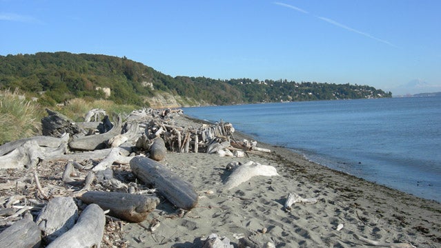
Though Seattle has no shortage of outdoor options within driving distance—the Cascade and Olympic ranges, Lake Washington, and Puget Sound, to name a few— the Emerald City also boasts serious recreational adventures within its city limits. Directly off the 33 Bus in Magnolia, Discovery Park features 11.81 miles of running trails on over 534 acres overlooking Puget Sound and the majestic Olympias. Forget you're in the largest city in the Pacific Northwest as you wind through old-growth forests and meadows, or run along sandy coastline near the lighthouse. Discovery Park is the best spot in the city to see area wildlife, including birds and marine mammals. On a clear day you can see Mount Rainier towering over the Seattle skyline to the south.
Getting There: From Pioneer Square, take the 33 Bus to E. Magnolia from the 3rd Ave. and James stop, get off at W. Government Way & 36th Ave. and check in at the visitors center for a park map.
Travel Time: About 30 minutes.
New York City: Hiking the Breakneck Ridge Trail
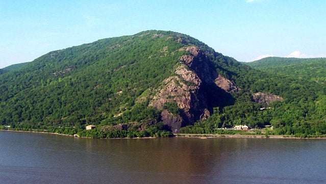
While not as steep a trek as climbing the Empire State Building's stairwell, the Breakneck Ridge Trail hike will give New Yorkers a run for their money. Only an hour north via the Metro-North Hudson Line, the hike is considered one of the most strenuous hikes in the East Hudson Highlands, but also the most rewarding. Take in panoramic views of the Hudson River as you rise over 1,600 vertical feet in less than three miles. Uphill travel and occasional rock scrambling is broken up by several lookout spots offering views of the Hudson Valley's bounty, including Storm King Mountain and Bannerman's Castle. Hikers should follow the Breakneck Ridge Trail's white blazes until they meet up with the Wilkinson Memorial Trail's yellow blazes leading back down to the road (the total loop is 2.8 miles). As always, hikers should not travel alone and should bring proper footwear and water as this hike is technical at times.
Getting There: From Grand Central Station, take the Metro-North Hudson Line to Cold Spring station and walk north along 9D until reaching the trailhead. On weekends, there is a train to Breakneck Ridge station, which is slightly north of the trailhead along 9D.
Travel Time: About 60 minutes.
Austin: Rock Climbing along the Barton Creek Greenbelt
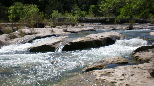
Austin is a city renowned for its live music, its tech scene, and keeping things “weird.” But perhaps one of the most unusual things about Austin is the amount of challenging rock climbing in the area. Just minutes from the capital's downtown area, the Barton Creek Greenbelt is home to over 15 rock climbing spots, including the well-known Seismic Wall, a limestone face with about about 30 different sport routes, ranging in difficulty from 5.6 to 5.12. The area is just a short hike down the Spyglass Trail coming from the Barton Skyway side. The Seismic Wall sits in the beautiful Barton Creek Beltway, a 7.9 mile-long, 809-acre expanse of lush vegetation, sheer cliff walls, and accessible swimming areas connected by dirt trails.
Getting There: From the Texas Capitol, hop the Capital Metro Route 30 bus and get off at the Spyglass Drive stop. Access the Greenbelt via the Spyglass Trailhead, a short walk south, and follow the trail until you see the Seismic Wall across a (usually) dry creek bed.
Travel Time: About 30 minutes.
Los Angeles: Hiking in Griffith Park
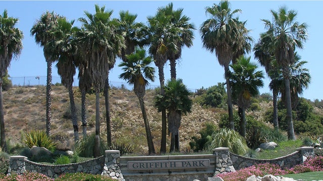
Los Angeles, the land of broken dreams, is also a land of broken trail. Lying in Hollywood's backyard, Griffith Park is home to over 50 miles of trails spread over 4,000 acres, proving that it offers more than just a big sign. Forming the eastern edge of the Santa Monica Mountain Range, Griffith Park hosts a number of hiking and running trails ranging from mellow to steep. Most impressive perhaps is the feeling of natural isolation despite the urban sprawl below. Griffith Park is considered one of the biggest urban parks in the nation and provides no shortage of activities including but not limited to, hiking, trail running, mountain biking, and horseback riding, all just a short bus ride from Hollywood Boulevard. Take time to connect with the Beacon or Bridle trails or explore Brush or Aberdeen canyons to get your outdoor fix.
Getting There: From El Capitan Theater, take the 181 Bus eastbound to the Los Feliz/Riverside stop. Walk north a short ways along Crystal Springs Drive and look for trailheads leading into Griffith Park. Look for Beacon Trail signs.
Travel Time: About 15 minutes.
Portland: Trail Running on the Wildwood Trail
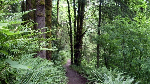
One of the most unique urban trail runs in the world, Portland's Wildwood Trail is 30 miles of pure outdoor bliss. Consisting of dirt track meandering through the lush fern beds and towering pines of the Oregon city's temperate rain forest, the Wildwood Trail remains a hidden gem to most of us despite its popularity in the Rose City. The trail is part of Forest Park in southern Portland, the largest urban park in the United States and an area designated to naturally purify the air, collect water, and control erosion within the city limits. There is no shortage of wildlife in the area with over 112 bird and 62 mammal species to take in on long wilderness runs. The trail hosts several organized races, including its own marathon every year. The trail is accessible via Macleay Park and the TriMet 15 Bus stop at 2960 NW Upshur St.
Getting There: From Jeld-WeN Field, take the eastbound TriMet 15 Bus to the stop at 2960 NW Upshur Street. Look for the Lower Macleay Park Trailhead to connect with the Wildwood Trail (about one mile).
Travel Time: About 30 minutes
Boston: Hiking and Climbing at Blue Hills Reservation
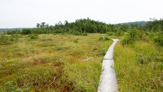
Just a short ways out of the Boston Hub, Blue Hills Reservation is a 7,000-acre four-seasons park accessible via city bus. For hikers, connect with the Skyline Trail trailhead near the Shea Ice Rink off the 238 Bus. The iconic trail crosses nine miles from east to west, skirting the ridgeline that touches most of the area's peaks. Out and back could take a majority of the day, but the diverse terrain offerings and well-marked blue trail are worth it. Grab a trail map from the reservation's visitor's center, as the area has over 125 miles of trails. For rock climbers, Quincy Quarries features a series of technical routes ranging from beginner to expert. From the top of the quarries take in sweeping views of downtown Boston and the adjacent Harbor Islands.
Getting There: From Boston Common: From Park Street stop take the Red Line (Braintree Line) to Ashmont Station. Take Bus #238 outbound to the West Street and Willard Street stop. Across the street is Shea Skating Rink, and next to it the St. Moritz Pond Nature Trail, entrance to the reservation trail system.
Travel Time: About 45 minutes.
Minneapolis: Cross-Country Skiing in Theodore Wirth Park
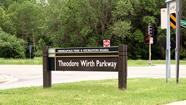
Five months of winter shouldn't automatically signal hibernation. Just ask the city of Minneapolis. Every year, outdoor enthusiasts in the Minnesota metropolis continue to hit the trails around the city, albeit on skis. Nordic skiing is a huge draw for locals, and directly off the Metro Transit 9 Bus, residents can strap on their planks and hit over seven miles of groomed cross-country trails in Theodore Wirth Park. From there connect with the Loppet course and cover 33km of trail through woods, over parkways, and next to lakes—all within city limits. Every year the area holds the City of Lakes Freestyle Loppet, an urban Nordic skiing race that draws over 1,200 people. Theodore Wirth Park is a great starting point, but with proper snow there are plenty of trails throughout the city. Check out local coverage at .
Getting There: From the Target Center, get on the 9B Bus at the Glenwood Ave./Wayzata Blvd. stop and get off at the Glenwood Ave. & Wirth Park Beach stop, and look for groomed trails. Some trails may require a paid pass.
Travel Time: About 20 minutes.
Salt Lake City: Mountain Biking the Wasatch Crest Trail
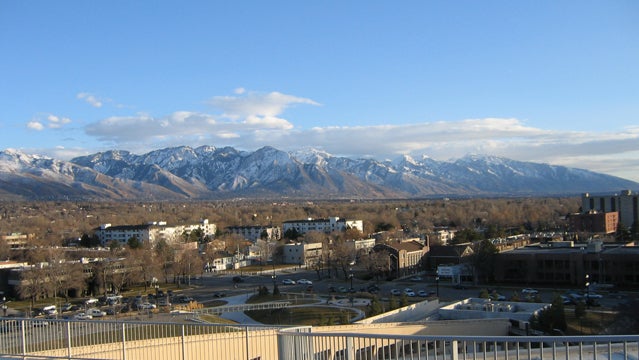
Salt Lake City has one of mountain biking's ultimate glory laps in its backyard. The Wasatch Crest Trail is 20-plus miles of well-maintained singletrack that runs in and around old-growth forests, alpine lakes, open meadows, and rocky ridgeline with incredible views of Big Cottonwood Canyon, Park City, and Salt Lake City. The trail is only open from July 1 to November 1, but the ride is one of the best ways to enjoy a summer day in the stunning mountains of Utah. Take your time or charge through, the trail hosts all types of riders, but is only open on even numbered days of the month for biking. The most popular access route is to take a metro bus to the 3900 South Wasatch Boulevard Park & Ride (there are several that stop here) and catch the cheap shuttle to the top of Guardsman's Pass, riding down the Crest Trail into Mill Creek Canyon. Those looking for the added burn can do the route in reverse, turning around at the transmission towers along the Wasatch Crest, for a longer, more strenuous ride.
Getting There: From the University of Utah, take the 354 Bus to 3900 South Wasatch Boulevard Park & Ride and catch the Wasatch Crest Shuttle (it costs $15) to the top of Guardsman's Pass. It makes limited runs, so check the schedule beforehand. For the reverse route, take Mill Valley Canyon Road up to the Big Water Trailhead to connect with the Wasatch Crest Trail proper.
Travel Time: About 60 minutes.
Knoxville: Canoeing the Holston River
Sometimes being in a city can really make you miss being on a clean mountain lake or river. Sure, many cities are built along rivers or the coast, but very few of these options could be considered a viable water recreation option. Knoxville, Tennessee, however, has promoted its waterways, the Holston and Tennessee Rivers, offering canoe launches and lessons. Starting from Holston River Park, willing watermen and women can take canoe tours right into Knoxville downtown. Clinics can run a pretty penny ($20 for short tours, $40 for longer tours), but canoes are provided. Buses running from Knoxville Station can take you out close to the park, and it's just a short walk to the canoe launch from there. Call ahead for reservations and enjoy a day on the water instead of battling midsummer humidity on the street.
Getting There: From Knoxville Station take the 32 Bus to the stop at Boyds Bridge Pike. Walk down the road and take a left on Holston Hills Road. The road connects with the park.
Travel Time: About 40 minutes.
Juneau: Hiking to the Mendenhall Glacier
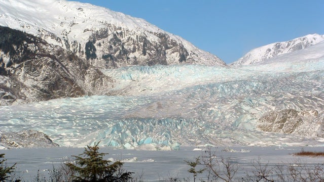
Not many cities can boast glaciers in their backyard. Even fewer can boast glaciers along a public bus route. Except, that is, Juneau, Alaska. A 45-minute bus ride from the Juneau Public Library will land you at the base of the West Glacier Trail, a 6.8-mile round trip hike to the stunning Mendenhall Glacier. Rising up through misty Tongas National Rain Forest, the trail is well maintained and marked and has several bridge crossings of clear glacial fed streams. The hike is intermediate and ends with incredible views of the glacier, Mendenhall Lake, and the surrounding rain forest region. For those looking for an added thrill, there are a few spur trails that lead right down to the glacier to explore ice caves and other natural features created by the ice flow. This is not advised due to the shifting nature of the ice, but for those that take proper precaution, the experience is unforgettable.
Getting There: From the Juneau Public Library, take bus route 3 to the Montana Creek Road stop. From there you should be able to see the West Glacier Trailhead.
Travel Time: About 45 minutes.