

57 Feet and Rising
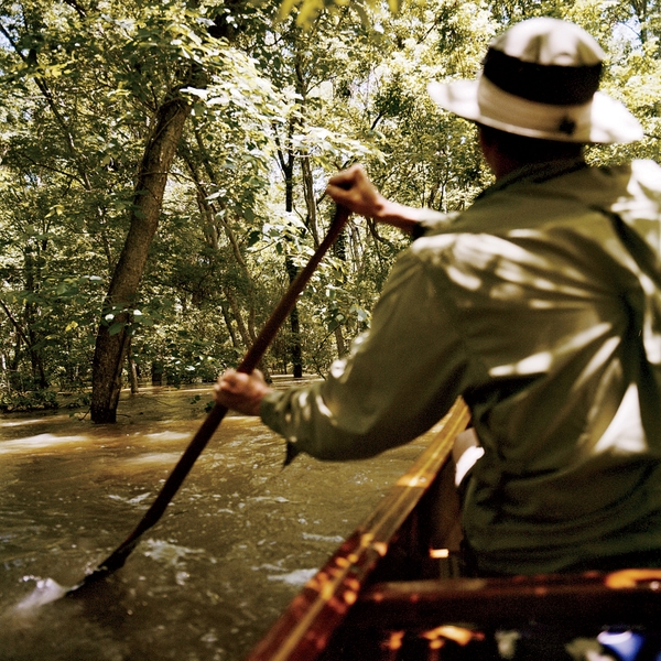
During the Great Flood of 2011, the Mississippi was an unleashed monster, with deadly currents and a flow rate that could fill the Superdome in less than a minute. Defying government orders, Delta native W. Hodding Carter and two wet-ass pals canoed 300 miles from Memphis to Vicksburg—surfing the crest, watching wildlife cope with the rising tide and assessing 75 years of levee building.
New perk: Easily find new routes and hidden gems, upcoming running events, and more near you. Your weekly Local Running Newsletter has everything you need to lace up! .
“What’s wrong?” I asked John Ruskey. He slowly closed his cell phone. Glancing toward photographer Chris LaMarca to see if he was in earshot, he gazed at the churning Mississippi.
It was our second day canoeing the , and the river was hurling us southward at a rate of almost 100 miles a day.
“My wife,” John finally answered, shaking his head. “Somebody told her there’s a shoot-to-kill order for anyone on the water.”
This was bad news. On May 16, we had sneaked a canoe into the river in Memphis, Tennessee, setting off to paddle 300 miles downstream to Vicksburg, Mississippi. We knew, of course, that what we were doing was illegal. On May 13, Mississippi governor Haley Barbour had issued an executive order banning all nonofficial watercraft from the flooded areas. But we couldn’t resist. Since 1998, John has worked as the only paddling outfitter on the Lower Mississippi, and I grew up in the Delta, exploring its rivers and bayous since elementary school. This was our chance to see the Old Man the way he’d been in his prime, before levees channeled the river in a controlled path around New Orleans and out to sea. Now, however, with the water raging at two million cubic feet per second—churning up football-field-size boils, countless whirlpools, and other dangers—getting shot was just one of our concerns.
Water levels like this hadn’t been in the forecast for the spring of 2011. Unlike the , the previous high-water event, this one had literally dropped out of the sky—just weeks after southern farmers had planted heavily to cash in on rising commodity prices for everything from corn to soybeans. Although there had been an impressive amount of snowmelt bulging the river in early spring, that had pretty much run its course by planting time. Then, from April 14 to 16, the storm system responsible for one of the largest tornado outbreaks in U.S. history dumped record amounts of rain in the middle and lower Mississippi River Valley, engorging the river almost overnight.
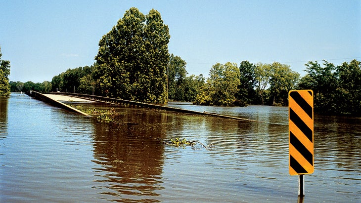
Four more systems hit in the weeks that followed, quickly producing some of the highest water levels ever recorded on the Mississippi. The river rose to 61.5 feet at Cairo, Illinois, to 47.7 in Caruthersville, Missouri, and to 47.8 in Memphis—each mark near or above local flood stages. All along the lower half of the river, in Tennessee, Arkansas, Louisiana, and Mississippi, the water was cresting at or near levee-topping heights, threatening 6.8 million acres of farmland and town after town after town.
The big question was whether the levee system would hold. After the devastating flood of 1927 submerged 27,000 square miles, killed more than 200 people, displaced 700,000, and wrought property damage estimated even then at $347 million, Congress ordered the U.S. Army Corps of Engineers to construct or improve the world’s largest system of levees, dams, and floodways—including 2,300 miles of mainline levees extending from Missouri through Louisiana. The still-unfinished project was largely completed in the 1980s, but the Corps’s work had never been tested like this before, and officials were doing everything possible to shore up the levees: piling on additional riprap, sheathing entire structures in plastic, and stacking up sandbags.
Since even the tiniest damage to levees can lead to river water pouring through, state and federal officials had stationed armed personnel along them to discourage anybody—terrorist or sightseer—from coming close. Back in 1927, similar armed patrols guarded the levees for hundreds of miles on both sides of the river. In Rising Tide, John Barry’s definitive 1997 book about the ’27 flood, Barry quotes an anonymous telegram sent to the governor of Louisiana and published in the press that warned river captains, “The next boat that comes down at such high speed will need two pilots, as we intend to kill the first one. Our guards are armed with Winchesters and they have orders to shoot to kill.”
In the best of times, canoeing the Mississippi is considered madness, even for a professional like John, whose long dark hair, full beard, and heavy mustache seem straight out of central casting for a backwoods river god.
Now 47, he first arrived in Mississippi in 1983 by riding down from Winona, Minnesota, on a raft constructed from scrap lumber and old steel oil drums; he stayed to play the blues and set up a guiding operation, the Quapaw Canoe Company in Clarksdale, in the heart of the 11,240-square-mile alluvial crescent known as the Mississippi Delta. John’s canoe trips are unparalleled, but even so, people there think he’s a little nuts for wanting to be out on the big river.
I know the feeling. As I learned growing up along the riverside town of Greenville, Mississippi, “good” people just don’t mess around with the river. Local author David L. Cohn, who wrote about the area from the 1930s through the 1950s, once claimed that folks in the Delta fear only two things: “the wrath of God and the Mississippi River.” Most people I know down there might occasionally tempt the former—but never the latter.
That’s why I nearly soiled my trunks the second we saw two stubby aluminum motorboats—the regional vessels of choice for law enforcement—racing at full speed to intercept us after they’d appeared out of nowhere 100 yards downriver. By the time we could make out that they were Bolivar County Search and Rescue, John quietly announced from the stern that a third boat was approaching from upriver.
John ever-so-casually ruddered the canoe away from them, out toward the main channel. Ignoring my pounding heart and a lifelong commitment to avoiding the law, I thwarted his escape plan, performing a hard cross-draw and aiming the bow directly toward the posse. Once we were close enough, I went into full-on good ol’ boy.
“What y’all doing out here?” I asked nonchalantly. “Great day to be out on the water, idn’t it?” The five men to our right didn’t even blink, but the big guy driving the downriver boat barked, “Where’s y’all’s license?”
“My license? In my drybag. We’re out here working for ���ϳԹ��� magazine, but with weather like this it sure doesn’t feel like work!” Not even a smirk. Chris, with his northern accent and hipster facial hair, had wisely stayed silent, but maybe John’s instinct had been wiser. The big guy asked for my license again. Stalling, I asked if he meant my driver’s license.
“Naw, boy,” he answered, with an exploding grin. “Your insanity licenses—’cause you boys are crazy!” Then, as if this had been their plan all along, all 15 guys started laughing and telling us we better get our asses over to the Arkansas side, where it wasn’t illegal to be on the water. After I told them my mama would never forgive me if I drowned in Arkansas, they laughed even more, took our pictures, and sped off. Now, at least, we knew one thing: since only a fool would be paddling this out-of-control river—and fools aren’t worth shooting—we were safe. Blessed be the insane.
I’d come to this misadventure honestly. I’ve spent much of my adult life paddling in far-flung waters—from guiding the Class V rivers of West Virginia to sailing a replica Viking ship in the Arctic Circle. But when the 2011 flood hit, I was still working on my long-term project of traveling, in broken stages, the Delta’s circumference by boat. I had already paddled the Big Sunflower and Yazoo rivers, which form the region’s eastern and southern boundaries. The Mississippi would just about bring me full circle to where I grew up.
It was my grandfather, the second W. Hodding Carter, who taught me to love the Delta, and in particular Greenville, which for decades was its most prominent city. He was owner and editor of the Delta Democrat Times, and he always called things as he saw them—which, in the immediate post–World War II era, meant arguing in favor of equal education for “Negroes.” His outspoken editorials won him a Pulitzer Prize, as well as lifelong enemies like the White Citizens’ Council, a bastion of militant resistance to desegregation that assailed him during the 1950s and ’60s with threatening anonymous phone calls and advertiser boycotts.
His escape? The river, including Lake Ferguson, which had formed between the Mississippi and the rebuilt town of Greenville when the Corps cut off an oxbow from the main channel in the 1930s. Big, as we called my grandfather, went there to fish, once hauling up a five-foot blue catfish; to hunt deer with each of his three sons; and to net the delicate river shrimp (now in severe decline due to channelization and pollution) that were once common fare for steamboat lunches. He wrote many books about the area, but two specifically concerned the river: one, Lower Mississippi, a natural and human history for Farrar and Rinehart’s Rivers of America series, the other a hyperbolic coffee-table book called Man and the River. Every page extols the river’s beauty and virtues.
Although Big moved to the Delta well after the flood, he knew that his adopted town, and the entire area, owed its continued existence to the new and improved levees, especially given that, old-timers say, some of Greenville’s downtown buildings were buried under Lake Ferguson. To his way of thinking, and to many in the Delta even now, the engineers and officers of the Corps could do no wrong as they turned bayous into drainage ditches, connected backwater levees to mainline levees, constructed hundreds upon hundreds of stone dikes (“wing dams”) to deepen and maintain the main channel, and sliced out countless cutoffs to drain floodwaters. Everything the Corps did was OK because its ultimate goal was to protect the Delta’s towns, farms, and livelihood.
If we weren’t defeated by massive currents or antsy levee guards, we would come closer to experiencing America’s greatest river in its natural state than anyone had in 75 years.
But today the Delta is mostly a depleted, depressed region with a shrinking population. In Greenville, a painful number of businesses are boarded up downtown, and one-third of the population falls below the federal poverty level. Bad as these facts may sound, the river has fared even worse. As far back as I can remember, its definable features have been its muddied water and the irrepressible Mississippi funk, a suffocating mélange of rotting mud, decaying fish, fertilizer, and some unidentifiable industrial by-product that is probably best not dwelled upon, at least when you’re swimming in it. Each spring the bloated river, choked with nutrient-laden agricultural runoff and channeled by levees, races straight into the Gulf of Mexico in unnatural volumes, setting off such dizzyingly fast-paced algae growth later in the summer that the plants use up all the surrounding oxygen. This process creates oxygen-free dead zones, huge swaths of lifeless ocean that first appeared in the 1970s. The record dead zone, in the summer of 2002, covered 8,500 square miles, larger than the state of New Jersey. This year’s is predicted to be at least 5 to 10 percent larger.
Yet, in mid-May, as the river was predicted to crest at 65 feet and urged citizens to stock up on water and fill up their gas tanks, we couldn’t help but be excited. The same force that led others to fight or flee the river was the same force drawing us (in Faulkner-speak) inexorably toward it. Rising dozens of feet higher than its normal level, the river simply swept over the confining wing dams and, gathering swollen tributaries under its arms, spread itself far and wide.
Two mornings earlier, our crew of three had been skulking around downtown Memphis in John’s massive Suburban, trailing a huge wooden canoe. John was circling the same eight-block area of upscale residences on Mud Island—the tourist-friendly peninsula that juts into the Mississippi River—but failing to find the semi-secluded launching area that had been suggested by a friend. His worried look made me realize that his most recent high-water adventure, in 2008, was still bothering him.
“I guess I should tell y’all, I almost got arrested before when we tried this,” he’d said on the drive up from north Mississippi. We’d met the previous night at John’s headquarters in high-and-dry Clarksdale, but we didn’t hit the road until around midnight. Now we were still playing catch-up at 5 A.M.
“A bunch of do-gooders tried to get us for endangering minors,” John went on. “They couldn’t believe we were taking my friend’s two kids out on the Mississippi in a boat without a motor. As if the canoe hadn’t been the preferred method of travel on the Mississippi for thousands of years! The second we backed onto the grass, this old guy, the park superintendent or something, hops out and calls the cops, saying, ‘Don’t you see the stay-off-the-grass signs?’”
John shoved off minutes later; “Brother” Ellis Coleman, 55, a friend of his who serves as a part-time shuttle driver, was left standing in the water, holding the trailer, when the police arrived.
“John, these policemen have some questions for you!” he shouted across the growing distance, but John just paddled on. With Brother Ellis’s permanently calm demeanor, it was little surprise that no one got arrested. The lanky, implacable Delta native is brother—one of 13 siblings, thus his nickname—to popular blues musician James “Super Chikan” Johnson and the living embodiment of cool.
As John pondered where to launch this time, Ellis, again the designated shuttler, said, “What’s the matter? You don’t want to get arrested?”
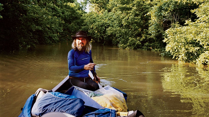
We finally settled on an overgrown field at the peninsula’s northern tip, which had been left alone thanks to its proximity to a sewage-treatment plant. We unloaded Cricket—a 24-foot bald cypress canoe, modeled after the classic Great Lakes voyageur boats, that a friend had made for John. Then we pulled on lightweight wetsuits (“Just in case!” John suggested, smiling), ate a handful of dewberries, and headed for the Mississippi.
“Hope you get arrested!” Brother E. yelled again and again, waving his straw hat as we entered the wide current.
“Are we going to see Ellis later?” Chris asked. “I’d love to go hit a juke joint or something with him.”
John, who had already begun banging on the Cherokee tom-tom he plays at the start of most paddling trips, paused to say, “Not a bad idea. Ellis is known as a lady-killer on the dance floor.”
It had been my idea to start in Memphis. I’d hoped to launch as close as possible to the Peabody Hotel, the folkloric northern terminus of the Delta. (Long ago, David Cohn wrote that it “begins in the lobby of the Peabody Hotel and ends on Catfish Row in Vicksburg.”) But the floodwaters hadn’t reached that far, so Mud Island it was. After pushing off, we paddled south, halting briefly to admire a flooded diorama of the Lower Mississippi. It had been cordoned off and pumped free of the real Mississippi River water so that clear, fresh water could be reinstalled. A little farther below Mud Island, work crews were clearing huge fields literally carpeted with garbage.
Although we were starting six days after the river had crested in Memphis at almost 48 feet, the current hadn’t let up much. Judging by roadside mile markers that poked above the floodwaters, we were moving along at ten knots—11.5 miles per hour—and we weren’t even paddling in sync yet.
I’ve ridden fast canoes, but never for more than 100 yards at a time. Consistently clocking between ten and twelve knots that first morning was a thrill, but as the day wore on, my muscles wore down. Although the river’s famous counterclockwise-moving boils—formed by the powerful bottom current that spins out boat-swallowing whirlpools as it hits the surface current—had not been dramatically multiplied by the increased volume, every stroke seemed like a tug-of-war, almost as if the river didn’t want us going faster than it. Chris, new to paddling, sat in the middle a few feet behind me. I could make out his every stroke and, and though I’d expected ever-increasing lily dipping, he remained solid, even keeping pace with John when I started to nod off at the end of the day. I was tempted to smack him when he said how good he felt.
“What is it about paddling a canoe, John, that seems to massage away any soreness?” he said. “I was hurting a couple of hours ago, but the repetitive motion has worked the pain right out of me. Isn’t it amazing, Hodding? This is why you like it so much, right?”
“Oh yeah,” I scoffed. “Incredible. I haven’t gone on a 100-mile-a-day paddle in ages, but I feel better now than when we started.”
Around 8 P.M., we were already far to the south—near where the river passes Clarksdale—headed for a clump of willows peeking above the water’s surface.
“Camp!” John hollered out cheerfully. He had to be kidding. We’d brought hammocks for tree stringing—there’d be no land to camp on—but even I could have found better trees than these battered sticks.
“Can you camp on driftwood?” Chris asked, pointing to a 40-by-20-foot mat of woody, junky debris we’d tied up next to.
“I’m not sure,” John said. “Sometimes the current packs it in tight enough to walk on, but I’ve never camped. I guess it will hold.”
As I tied us off, John hopped “ashore,” quickly walking toward the upstream edge. “I’ll get a fire going so we can at least have hot coffee,” he said.
Clocking between ten and twelve knots was a thrill, but as the day wore on, my muscles wore down. Every stroke seemed like a tug-of-war, as if the river didn’t want us going faster than it.
Chris and I helped each other onto the nearest log and inched forward. The debris was solid, several feet thick, and littered with trash—plastic soda bottles being the most prevalent item. There was a lot of dry wood in the middle, so we started a fire on … an island of wood. I wolfed down a quinoa salad John’s wife had made and then stumbled toward my bed—the bow of the canoe. I was deeply shimmied into a bivy sack when I suddenly bolted upright.
“Guys!” I yelled. “Can you believe this? We’re camping on an island of driftwood, floating 40 feet over the nearest land!”
That wasn’t the only great thing. Once we’d put the first 50 miles or so between us and Memphis, that old Mississippi River funk had vanished. In its place, a sandy, willow-sweet aroma had silently risen from the surface. Even the river’s color had morphed: from ag-runoff, milk-coffee brown to a confident and glistening gray.
“Only one tugboat passed us last night. Did y’all see it?” John asked eight hours later, moments after banging a metal cup against a plate to wake me up. John had been awake since three, thanks to his unshakable sense that Driftwood Island was falling to pieces—not a big surprise given that he’d slept a mere yard from the edge. By morning’s light, though, it looked a few logs bigger.
“It was the strangest thing,” he continued. “Never seen a river pilot act this way. When I couldn’t go back to sleep—your snoring didn’t help, Hodding—I relit the fire, and it was glowing brightly when he pushed by, headed upstream. Unmissable. But he didn’t shine his spotlight on us.”
Having once traveled the length of the Missouri in an inflatable boat, I knew exactly what he was talking about. River pilots always soak a campsite in blinding light—for safety reasons, or amusement, or maybe just in hopes of spotting skinny-dipping women. “I think he was afraid of what he might see,” John said. “‘A raft of driftwood with a fire on it? Has to be some sort of apparition!’ These pilots are very superstitious.”
Some of them could also be a little hostile. We’d passed one headed upstream and another headed down, and neither liked sharing the river with the likes of us. We had a radio, so we could hear the downstream guy warning the upstream guy that we were in the way. He said he’d called the Coast Guard to arrest us. The other pilot signed off by hoping we’d get washed against a stand of cottonwoods and flip beneath them.
Nice. For the record, though, most of the pilots we encountered were respectful if not friendly. We would pass a dozen more tugs, and no other pilots wanted to crush us. One went so far as to call us “brave souls.”
The river continued to expand in width and power throughout the second day. With each passing hour, we crept closer to the highest water—meaning we were riding the largest freshwater wave ever. In Rising Tide, Barry recalls a study in which a Mississippi flood crest was clocked traveling at almost twice the speed of the average current. “The crest, in effect, was a separate layer of water that skidded down the top of the river,” he explained. Miles wide and more than 100 feet deep, these crests have been shown to move at nine miles per hour for sustained periods.
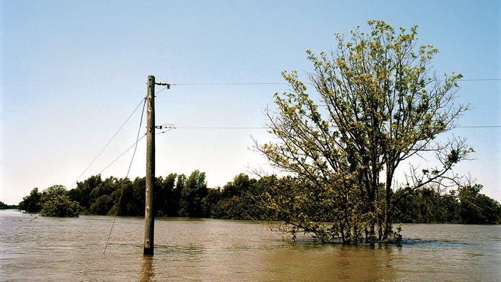
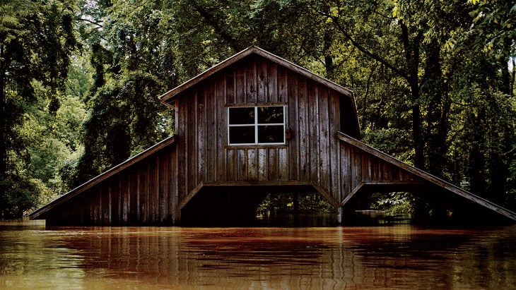
That’s an incredible amount of watery momentum, and we were seeing this force live as it swept us alongside, and sometimes over, weekend homes that were flooded to the rooftops. These were hunting camps, in local parlance, but more similar in size and value to summer cottages in Maine than to bedraggled backwoods shacks. We passed one 3,000-square-foot camp with a screen porch decked out with a 36-inch flatscreen TV that faced a six-person hot tub, now three feet underwater—a fitting punishment, perhaps, for soaking with your back to the river.
As we moved downstream, we aimed west, toward the Razorback side. John measured the swollen expanse of water at 19, 22, then 35 miles wide near its confluence with the Arkansas. This was the Mississippi unbound. Gone—submerged far below and in many instances torn apart—were the wing dams, the telltale islands beloved by John and used for navigation by tug pilots, and the lowland farms cashing in on the rich alluvial plains. Other than the tugs and those three law-enforcement boats, we had the entire river to ourselves.
Well, except for the doe swimming frantically toward the shoreline. By the time we noticed her, we were blocking her crossing. We paddled downstream, angling slightly to the east, so we could get below her and herd her back on course. But not knowing our good intentions, she decided not only to hold her ground in the 15-knot current but also to head upstream. We left her alone; the “stranded” deer was probably better equipped than we were to handle the raging current.
Libby Hartfield, director of the Mississippi Museum of Natural Science, would later explain to me that, despite frenzied media stories to the contrary, the creatures indigenous to the Mississippi River’s floodplains do just fine in high-water events. Fish, for example, from gar to catfish to the endangered Mississippi sturgeon, move into the calm, warm floodwaters and explode in size and number. It’s true that some animals don’t adapt well: individual deer, wild hogs, and nesting turkeys forced to higher ground sometimes die, along with abandoned domesticated animals, if the waters take too long to recede. But most populations thrive in the end, thanks to the regenerative effects of the floodwaters. Biologist Brad Young, who leads the Mississippi Wildlife, Fisheries and Parks Department’s black bear program, told me he’d checked on radio-collared bears from the air and they were all accounted for, feasting on trapped bugs and snakes. “Bears love to swim, and they love to climb trees,” Brad explained. “What’s not to like about a little flooding?”
It was about then that John announced, “Time for the afternoon swim.” He swims every day he’s on the river, but this was the first time I actually wanted to join him. The water was cold, somewhere around 60 degrees, and refreshing. When I looked toward shore—marked by a line of half-submerged trees—I realized we were still racing onward, us three bathers and the bobbing, headless canoe, at one with the approaching crest.
It was about then that John announced, “Time for the afternoon swim.” He swims every day he’s on the river, but this was the first time I actually wanted to join him.
It was a great but melancholy sensation—feeling a part of this river that was now wilder than it had been in decades. It’s not that we didn’t lament the destruction around us. Mississippi’s farms alone would suffer $250 million in damage, and it would be weeks before people in low-lying communities, like the upper Delta’s Tunica Cutoff, could visit their homes, let alone begin to face the heartbreaking decision to restore, rebuild, or move on. That decision would be played out up and down the river in the coming weeks: early estimates showed close to 10,000 people displaced by the flood and $4 billion in damage to homes, businesses, infrastructure, and farms.
Clearly, given the devastation of ’27, America’s engineers had done right to try and make life along the Mississippi safer. But the current system’s complete reliance on containing and draining had too many drawbacks. Besides the expanding dead zone in the Gulf, there were far too many natural flood basins being protected by floodgates, pumps, and levees that, at great expense to taxpayers, kept land open to only a handful of farmers. These flood basins exist all along the river, and environmental organizations like American Rivers, in conjunction with federal and state officials, Gulf of Mexico fisheries representatives, and fishing and hunting conservation groups, are promoting policies that would restore them.
Under this alternative vision, reclaimed floodplains would again support plants and animals indigenous to the area’s bottomland hardwood forests, only slowly releasing runoff downstream. This would also alleviate pressure on the swamps of the Atchafalaya Basin, which were inundated by the deluge of water released in May through the Morganza Spillway northwest of New Orleans. In strategic areas, levees would be moved back or notched to reconnect the river with its floodplain.
“We need to give the river more room to move,” says Andrew Fahlund, vice president of conservation for American Rivers. “Unless we restore our natural defenses, we will burden future generations with increasingly disastrous floods.”
While I’d always agreed with the idea of controlling the Mississippi naturally, that was in the hopes of helping the Gulf of Mexico and the wetlands up and down its banks. Now, after experiencing the Mississippi when it was clean-smelling and free, I felt like the river itself deserved a change.
That night we camped at a place on the Mississippi that I knew from childhood—one that had taught me a lifelong lesson. It was a steep, 30-foot-tall set of sandy bluffs at Leland Neck, on the Arkansas side. Always a natural beacon in the flattened Delta landscape, it was also, on the night of May 17, the only piece of dry land for miles.
In 1972, my grandfather Big died when he was only 65, worn down, perhaps, by the years of fighting his enemies—and most definitely from drinking. Who could blame him for turning to alcohol, though, when an entire state reviled him? To pay the bills and prepare the way for selling the Delta Democrat Times, my family and their business partner sold off some of the paper’s more extraneous, high-end items. The 40-foot cabin cruiser Mistuh Charley went in June of ’76, the year I turned 14—but not before I, in a fit of anger, liberated the 12-foot lifeboat strapped to its roof. The little dinghy was a covetable example of craftsmanship, with its sleek lines, wave-slicing V hull, and dashing teak rail. But all I cared about was that it had a temperamental little 12-and-a-half-horsepower outboard.
My parents were splitting up that summer, and my dad, who’d taken over editing the paper, was out on the campaign trail with Jimmy Carter. Back home, there were only a minimal number of rules governing our lives. Two family statutes, however, remained absolute: (1) Hodding shalt not swim anywhere near the river, and (2) Hodding shalt not be so dumb as to even think about taking that damned lifeboat onto the river. “Yes, ma’am,” I told my mother in all honesty. “Not a problem. I’m not that crazy!”
The next day, my friend Martin Outzen and I motored the boat across the river to Arkansas, hauling onto the sandy beach at Leland Neck. After swimming along the shore and throwing mud at each other, one of us had the bright idea to slide down the steep bluffs. The third or fourth time we’d trudged back to the top, Martin asked, “Hey, Hodding, doesn’t the boat look like it’s floating away?” The scorching heat had made the air thick and wavy, but even so, I could just make out a widening patch of water between the boat and shore.
We were potentially screwed. The bridge back to Mississippi was miles away, through impenetrable woods, and even if we somehow managed to get out to the road, there was still the matter of a 20-mile walk back to Greenville, where my mother’s wrath would await. “Go, go, go, go, go!” I yelled, and we slid down the hot sand as fast as possible.
It took me a few desperate seconds to mount the courage to dive in. By the time I did, the boat had drifted an eighth of a mile and was slipping into the main current. I took off and, swimming the fastest 220 yards of my life, caught up to it, scrambling over the gunwale like some gigantic marauding water bug and pulling the tiny outboard to life in a single frantic motion. I drove back to shore with the proudest grin. I didn’t know it at the time, but that rule-breaking swim set me free.
I’d been telling this story to Chris and John—raving for an hour about the Neck’s life-affirming, perhaps even mystical, qualities—when John announced, “It’s just around this bend.” The sun hung about a foot above the trees as if ordered up by Hollywood to highlight the beauty of my steep, sandy hills. Seconds later, there they stood—in all their two-foot majesty.
“Oh right, the flood,” I muttered.
Nonetheless, the former cliffs, now short, tiny islands, were awash in sunset glow, producing an immediate “Awesome” from Chris. “I can’t believe we have the only bit of land all to ourselves,” he sighed. “Now if I can just get far enough away from your snoring.”
As we soon saw, the islands were already occupied, by a raccoon and a feral pig. The raccoon waddled into the river and swam to a stand of cottonwoods 100 feet from shore that were loudly popping and rippling like a small set of rapids. The pig, a brown, scraggly specimen, stood his ground, at least briefly, squealing at us before snorting and skipping across the shallows to the adjacent bluff island 15 feet away.
We ate cold potato soup, then sat around another driftwood fire, lingering for hours.
“John, I’m totally getting you and this river,” Chris said enthusiastically. “It’s definitely gotten inside my head. Making me rethink my priorities. I want more of it.…”
“Yeah,” John replied, “It’ll do that to you. I have to get out here. Alone, if possible.” Then he invited Chris to come back and apprentice himself as a guide.
I slept like a stone, until, hours later, the scruffy pig returned. Perhaps attracted by my ripening river essence, he skittered over my sleeping bag, back to reclaim his turf.
The followind day was just as grand, with the river thundering along at two million cubic feet per second, a volume capable of filling the Louisiana Superdome in 50 seconds. Fifteen miles south of Greenville, we tied off to a floating 40-foot willow tree fluttering with spring leaves and ended up covering ten miles during lunch. We were now less than 15 miles from Vicksburg, where the river, nearing its crest, was washing onto city streets and forcing residents to flee their homes. The main levee was holding, but what about the backwater levees and floodplains they protected? With that in mind, we went canoeing the Mississippi through its woods late that afternoon.
We were following an old river passage called Forest Home Chute. As we paddled through flooded stands of hardwoods, the trees formed a single intertwined canopy stocked with thousands upon thousands of songbirds. At times we had to repeat ourselves to override their mesmerizing, almost deafening, calls. Paul Hartfield, a local biologist with the U.S. Fish and Wildlife Service, had told me years earlier, as we canoed very near this area, that these woods depend on periodic flooding to thrive. Thick with sycamores, oaks, and sweet pecans, bottomland forests like these can then support migratory birds, from the endangered Bachman’s warbler to the recovering bald eagle. Maybe the birds were celebrating the crest.
I wanted the night to last forever. How often do you sleep with only a thin sheet of nylon and two feet of willow-scented air separating you from our largest river at its most powerful state in a century?
Around 6 P.M., we came upon two southern hackberry trees, their smooth white bark lit by the setting sun. They were bare of limbs for a good 15 feet above the river’s surface, shielded from the main channel by hundreds of yards of swell-dampening trees and spaced a perfect ten feet apart. We strung two hammocks, one about eight feet up and another about four feet lower. John had decided to stay in the canoe, no matter how many times we pointed out the abundance of space. Once I was safely tucked in, I wanted the night to last forever. How often do you sleep with only a thin sheet of nylon and two feet of willow-scented air separating you from our largest river at its most powerful state in a century?
If canoeing the Mississippi was a little bit of heaven, then our destination six miles inland, the Yazoo Backwater Area, was surely a taste of hell. The Yazoo used to be beautiful and clear, but these days it’s a muddy drainage ditch loaded with agricultural chemicals. It’s also a pawn in a high-stakes battle between entrenched foes fighting over the lower Delta. For years, the Corps and its local supporters have been trying to install the world’s second-largest drainage pumps in this sparsely populated 4,000-square-mile basin, even as U.S. Fish and Wildlife has been restoring tens of thousands of previously farmed acreage to wetlands. Simply put, this place is a mess.
We’d have to zigzag in, following Forest Home Chute to Paw Paw Chute and crossing a small oxbow lake to reach the Yazoo River, its flow now reversed by the surging waters of the Mississippi. From there it was just down a short canal to the backwater levees and the Steele Bayou floodgates, the last line of defense protecting these lowest of lands.
The chutes were a cinch to navigate. Telltale cottonwoods marked the submerged embankments on either side, and any culverts were way below us. Our troubles began when, after paddling down a six-foot-wide alley between trees that marked a submerged deer trail, we made it to the mainline levee only to find a shiny white SUV parked in a lookout position. This sent us sneaking back into the woods but, regrettably, not to the same deer trail. We had to resort to pulling and prying our way through dense forest. That’s when the trickling current suddenly went into flash-flood mode, forced through tighter forest as it spilled over a small abandoned levee. We found ourselves immediately running a high-stakes slalom course through tightly packed, sharp-limbed trees.
“Left, left!” I called—our only option if we were going to avoid smacking into a tree and instantly turtling. I pulled hard toward our port bow, and John turned her quickly. Dead ahead there was another tree ready to take us down, then another and another: Class II–III rapids mined with trees instead of rocks. Not a good scene, especially since Chris was still standing up, taking pictures. That’s when I missed a draw; we bashed sideways into two trees and started taking on water.
“Back-paddle! Back-paddle!” screamed John. Chris dropped his camera and, together, all three of us—after about ten minutes of frantic upstream ferrying, backwards—got to slower water and onto the Yazoo.
“These gates better be worth it,” Chris remarked. “I’ve never seen John actually lose his composure.”
After a short paddle on the backward-flowing Yazoo, we finally reached the Steele Bayou floodgate. Built in 1969 both to drain storm water and to keep floodwaters out, it creates an unnatural confluence of the Yazoo, the Big Sunflower, and Steele Bayou. Right now the gate was closed, holding back the swollen Yazoo from the lowlands that the other two waterways flow through. It was amazing to stand on the backwater levee and compare both sides. On the Yazoo side, the water had risen to the top of the levee, where work crews had piled dirt and rocks a foot high. On the Sunflower side, the water was more than 20 feet below us.
It was impressive, frightening, and maddening. Impressive because of the skill shown by the Corps. “You’ve got to hand it to ’em,” John admitted. “These structures are performing exactly as they were designed to.” Frightening because countless vulnerable farms and nearby towns stood on ground well below us. And maddening because none of them should be there. This area was called a floodplain for a reason—it’s supposed to be flooded when the rivers are high. If we would just restore enough of these traditional floodplains, then so much of the mess we’re facing—increasing dead zones, endangered cities, loss of habitat all along the Mississippi River corridor, and a polluted Atchafalaya Basin—would be cleaned up naturally.
The levee was impressive, frightening, and maddening. Impressive because of the skill shown by the Corps. Frightening because countless farms and towns stood well below us. And maddening because none of them should be there.
We took a shortcut back to Vicksburg, paddling across a large flooded farm and along the old flooded highway, and ended the trip near sunset, like we had the previous days. Only this time we were greeted by a crowd of onlookers—20 or 30 tourists, friends, and little kids held behind a barricade by the cops. Paul Hartfield, the biologist, had argued to the police that our ride from Memphis had been an important natural-science investigation. He must have been convincing in his uniform cap, because the police and strangers alike clapped heartily when we waded up Old Highway 61. We’d originally invited Paul to join us on our journey, but he’d had to pass due to a family illness. It was easy to see how he felt—smiling, but with a sad, wistful look in his eyes—when he shook my hand.
“You’ve seen the river as close to what it once was as possible,” he told me a few days later. “If 1927 was the flood of the 20th century, then 2011 is the flood of the 21st. When you’re an old man and the grandkids are asking Papa where he was in the Great Flood of 2011, you’ll be able to tell them, “Well, kids, I was surfin’ the crest.'”