

I have found the rock of truht (sic), but you probably won’t. Oh, it’s out there, one of several hippo-size stones in the sea of rocky desert that is Joshua Tree National Park. Just walk about three miles west from Quail Springs picnic area and bear north at the wash. You’re looking for a 50-foot pile of boulders rendered almost invisible by harsh light and the monochrome terrain. You may not see it until you literally stumble into it—not a bad metaphor, in fact, for the search for truth. These are Samuelson’s Rocks, a self-created monument to an old Swedish sailor turned prospector who devoted long years to carving his every thought into the faces of these impossibly hard granite stones.
It’s here that you’ll find the Rock of Truht. It announces itself plainly: “The rock of faiht and truht,” reads the first inscription on its side. Followed by “Nature is God.” And nearby, rather disconcertingly, “Wake up, you tax and bond slaves.”
As a lifelong habitué of Joshua Tree—I was born about 60 miles away—I’d often heard about Samuelson’s Rocks and these nutty and moving inscriptions laboriously cut into the stone 70 years ago. But I’d never bothered to seek them out until now. Like most J-Tree regulars, I’d usually come just for the climbing, rushing rather heedlessly to bag as many of the park’s 5,000-plus climbing routes as possible and grow my confidence on the awesome purchase of the grittiest granite on the planet.
But in recent trips I’ve come to realize that Joshua Tree is so much more capacious than its 5.8s and 5.9s, enthralling as those may be. It’s also a place of otherworldly beauty and mystery, a massive, stark, surreal landscape where private little monuments such as Samuelson’s feel not at all out of place. Hike past the skyscraping boulders or turn off the main roads onto long-abandoned mining tracks and this other Joshua Tree envelops you—lonely, silent, sere, and enrapturing. This is the heart of the Mojave Desert, where miners once dug gold from the sun-baked mountains, where chollas still outnumber climbers (though the climbers are gaining), and where faiht and truht lie embedded in the rocks, if you only know where to look.
Hidden Valley
There’s no Going-to-the-Sun Road in Joshua Tree—which is to say, there’s no true hub to the place. But Hidden Valley comes closest, given its accessibility and the access it in turn provides to some of the park’s most inviting terrain, including many of its best climbs. Try to arrive by way of the north entrance to the park—near the little town of Twentynine Palms—where there’s a visitor center with a bookstore, a nature exhibit, and a continuous-loop video that includes music from U2’s The Joshua Tree.
Less a true valley than a series of passageways amid huge boulder formations, Hidden Valley has always been climbing nirvana, especially in the Turtle Rock formation to the south and on the nicely named Sports Challenge Rock, the centerpiece of what climbers call Real Hidden Valley. (Plain old Hidden Valley is the campground across the road, by the way.) A mile-long nature trail skirts the base of Sports Challenge for those who just like to watch. Or you can accept the gauntlet and follow a short offshoot trail that leads east across a wooden bridge to free standing Hidden Tower. Like many of J-Tree’s routes, this one isn’t as difficult as it looks—the holds are there where you need them —but its sheer verticality makes the 5.9 ascent a heart-thumping rush.
Or consider doing what I do these days: leave the harness at home. The history of Hidden Valley is in a ghostly, insinuating way every bit as memorable as its handholds. Just 1.5 miles north of the campground is the Desert Queen Ranch, built by that Edison of desert survival, Bill Keys. This indomitable tinkerer (1879-1968) managed to wrest enough water from the desert to run a cattle ranch, power stamping mills at his gold mines, and irrigate an orchard. Today his ranch, empty for decades, is under the stewardship of the national park. Visit on a quiet, hot afternoon—the homestead is open to the public by prearrangement with park headquarters—and you may see bighorn sheep perched on a rock ledge above the schoolhouse while sunlight sparks off the slowly rusting carts and machinery. It takes guts and implacability to create such a pocket of civilization in the empty Mojave.
Of course, it also takes water, which Keys provided in part by building the nearby Barker Dam. If any rain at all has fallen recently, the dam’s mortared-stone barrier will catch and hold it—accounting for the improbable sight of a No Swimming sign in this bone-dry park. (To reach the dam, take the dirt road east from the campground to Barker Dam Nature Trail.) More likely, however, no illicit pool will tempt you, so you can instead continue along the trail to find the most vivid “pictographs” in the entire Mojave Desert—presumably painted onto the red rock by a 1950s Disney film crew to add a touch of “realism” to the 1961 movie Chico the Misunderstood Coyote.
Jumbo Rocks
The name would seem to be a synonym for most of Joshua Tree, but this campground about eight miles east of Hidden Valley is in fact home to several hundred-foot-high pates of monzonite granite that are perfect for scrambling and for a little geological pedagogy. Take Skull Rock, for instance; you’ll recognize it by the eye sockets. Most of the shaping of the monzonite here was done underground. Only when the upper layer of Pinto gneiss weathered away did the monzonite see the light of day. Surprise and impress your friends by remarking that Skull Rock’s declivities, which appear to be wind-carved, are actually the result of water erosion. Then coolly walk away.
In fact, walking is the best way to see Jumbo Rocks and the surrounding countryside, but don’t expect much in the way of signage. Even a fairly obvious trail, such as the one that leads three miles south from camp to an aerie known as Crown Prince, peters out near the base of the formation; from there, you’ll have to devise your own scrambling route to the summit. But you’ll be suitably rewarded: Your view sweeps 360 degrees out over much of the park, including westward to the often-snowcapped Mount San Jacinto and Mount San Gorgonio, the tallest peaks in southern California.
North of Jumbo Rocks, if you’re up to some cross-desert bushwhacking, you can forge a loop that includes a unique dwelling above Eagle Cliff Mine, a clever, makeshift stone hut built by turn-of-the-century prospectors. A faint path leads northwest from the Split Rock picnic area steeply up the side of unnamed slopes and then descends abruptly toward the mine. Scan carefully on the way down or you’ll miss the aforementioned highlight: Look for the live oak tree that marks the entrance to what is, in reality, a lean-to made of 30-foot-high boulders. Impecunious miners simply filled the cracks between the slabs with crude stone walls and put in a four-pane window—still intact, as is an ancient cast-iron oven. There’s something so haunting about the place that it’s been left undisturbed by the few hikers who’ve stumbled across it.
Complete the loop by forging a route south to Desert Queen Mine, once the source of much of Bill Keys’s income. The mine shafts have been screened over to avoid Baby Jessica-style tragedies, but you can peer into the darkness and imagine what it must have been like to emerge blinking from the tunnel into the bright, searing daylight. Shake yourself from this reverie and loop back east to the trailhead at Split Rock. The distance is only three miles total. But as with all of Joshua Tree’s best hikes, measurements are indistinct. Rarely will you feel so remote in time and space, especially at that moment when you peer through the miners’ dingy window into the home they wrested from the stone.
Wonderland of Rocks
Like plenty of other J-Tree climbers, I cut my teeth—and fingertips—at Indian Cove, on the northern fringe of a vast, dazzling maze called the Wonderland of Rocks. The Wonderland extends from the northern end of the park south all the way to Hidden Valley, a total of about seven miles. At Indian Cove, climbers ritualistically survey the day’s first climb over morning coffee, with the distance from breakfast to belay about a picnic-table’s length. Nearby is a great training ground called Short Wall, sporting a dozen or so routes rated from Class 4 to 5.11c, all readily top-roped, all with easy walk-offs. Deeper in the Wonderland are some of the most technically difficult climbs in the park—places like the Ivory Tower, whose La Machine (5.13d) remains only twice-climbed.
But by attaching themselves exclusively to the rock face, climbers are missing the most magical part of the Wonderland: Hiking here is in fact spectacular, especially the Rattlesnake Canyon route, which is about as much fun as day hiking gets. Beginning at the Indian Cove picnic area, head east and then south up the obvious wash. Then, using a topo map (there’s no marked trail), aim for the slot canyon, a skinny cleft that grows progressively narrower over the course of a mile until you’re scrambling, grunting, and bouldering your way up, ascending tiers into the depths of the Wonderland maze. Wander as far as you wish; just heed the abiding rule of desert hiking: turn back when your water’s half gone. It’s possible to cut all the way through the Wonderland to Quail Springs Road in Hidden Valley (14 miles one way). But it’s illegal to camp overnight en route.
For that ineffable experience, you’ll need to try the Wonderland’s classic route, the eight-mile Boy Scout Trail, which begins just south of the park entrance. Set up a car shuttle with a partner, register at the backcountry sign-in board on Indian Cove Road, and head off through the rocky Wonderland. The route emerges into open desert about five miles later. Camp anywhere and watch the star spectacle overhead. Next day, hike out to Quail Springs Road. Like all desert pilgrimages, this one should leave your soul lightened and refreshed. On the other hand, it’ll be damned hard on your corporeal self if you don’t carry sufficient water—about four gallons (yup, that’s 32 pounds) per person. But the hike is certainly worth the strain, and blessedly, the load gets lighter with each passing hour.
Samuelson’s Rocks
End your Joshua Tree sojourn by making a stab at finding this most evocative of sites. It won’t be easy: since it’s not marked on the USGS maps, you may have to beseech a ranger to circle it for you on your topo or provide you detailed directions; the best my guide could come up with was, “When you come to the wash that would take you south toward Johnny Lang Canyon, bear north instead.” In effect, then, you’ll just have to re-create Samuelson’s own journey, setting out blindly into the desert—though you’ll be starting from the relative security of the picnic grounds at Quail Springs. Bear in mind that you may never find the spot. (If you’ve been hiking for more than two hours, you’ve missed it.) But if and when you do, stay awhile. Shadows will lengthen. A raven may circle overhead. The air will settle on you, baked and dry. And the carvings of that odd prophet Samuelson will animate the stone.
“Study nature,” he chiseled. “Obey the laws of it, you can’t go wrong.”
“Water is soft,” he continued, warming to the theme, “but with time, the ocean can griend [sic] the hardest granit [sic] to a powdered sand. So with time will the human race grind out its own destinies.”
And at the tail end of the Rock of Faiht and Truht: “Evolution is the mother and father of mankind. Without them we be nothing.”
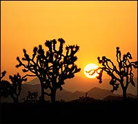
On the afternoon I found Samuelson’s Rocks, I left soon after reading this last of his aphorisms. The sun was getting low, washing the rocks in a soft, tarnished glow. The chollas appeared taller and thornier than ever; the Joshua trees, their arms uplifted to heaven, more devout. A languid coyote woke from a nap in the shade of a creosote bush, stretched, and yawned as I passed. I doffed my cap to him, looked at the silent, empty landscape all around, and thought, Without this, we be nothing.