

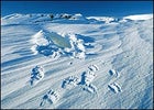
 Fresh tracks and a winter den left behind by a polar bear and her cub in the refuge’s 1002 region, March 2002
UPDATE: Senate Votes Against ANWR Drilling Provision ()
ON AN EARLY MORNING flight to Arctic Village in northeastern Alaska last July, our airplane crossed the forested White Mountains to Fort Yukon, at the confluence of the Chandalar and Yukon rivers, north of the Arctic Circle. From there we flew across the roadless barrens of the Gwich’in reservation, ascending the East Fork of the Chandalar and the caribou-tracked southern foothills of the Brooks Range, on the first leg of an expedition into the Arctic National Wildlife Refuge.
Arctic Village is an assembly of 40-odd spruce-log cabins that overlook the serpentine bends, oxbows, and channels of the East Fork. More than a hundred miles from the nearest road, it was settled by the formerly nomadic Gwich’in because its forest and river provided timber for fuel and shelter, furred animals, and abundant fish. More important, it is winter range for varying populations of the vast Porcupine caribou herd, an estimated 123,000 strong. Drifting across the mountains from their summer breeding grounds in the Arctic Refuge on the coast of the Beaufort Sea, the caribou move south and east into the Porcupine River drainage and Canada’s Yukon Territory, where most of the animals overwinter. The 15 Gwich’in villages in northeastern Alaska and northwestern Canada, which include about 7,000 people, are scattered along the caribou migration route, and each family needs eight to twelve animals to provide sufficient dried meat and hides to feed and clothe it through the long, hard winters. In 1971, Arctic Village and Venetie, a Gwich’in village 70 miles to the south, chose not to participate in the Alaska Native Claims Settlement Act. The act was offering nearly $1 billion and 40 million acres to settle indigenous land claims for those tribes that accepted oil development and the construction of the trans-Alaska pipeline, which carries crude oil 800 miles south from the Arctic coast by way of Fairbanks to the huge tankers at Port Valdez. Refusing the money, the two villages held out for the original tribal land claim of 1.8 million acres established under the Indian Reorganization Act, which was amended to include Alaska in 1936. Their brave commitment to the integrity of their ancestral lands has limited these Gwich’in to a life of bare subsistence, yet seen from the air, the solid cabins built among the conifers show a strength of spirit that is evident in the calm presence of Evon Peter, the young village chief, who came to greet our plane on the gravel airstrip.
Peter, a slight, handsome man of 26 who recently earned a B.A. in Alaska native studies from the University of Alaska in Fairbanks, gazed around his mountain country as if inviting me to appreciate it with him in the few hours I had to spend walking the village. “We’re certainly one of the poorest tribes,” Peter said, “yet we’re also rich, for we have our unspoiled original land, and we have our language and our traditional way. We want to remain independent as far as possible; we want sustainable energy, solar power.”
We crossed the village and climbed a hill to visit Sarah James, the Gwich’in spokeswoman for the Arctic Refuge. She greeted us from the doorway of her house. “Yes! We got plenty of good food here! Better come help eat it!” said Mrs. James, 57, a friendly, bespectacled person rounded out by a full life. “King salmon from the Yukon—that’s the best there is!” She waved us through her door ahead of the mosquitoes, bustling back to her small stove to put the last touches on a fine, big feed of salmon and caribou stew.
For many years, Sarah James has spoken out against development in the refuge. “I only repeated what Indian people have always said about land and life, but this time we got heard because of the big fight over our caribou and their breeding ground,” she said. The caribou have sustained the Gwich’in culture for many thousands of years, and the annual coming of the big deer is so critical to Gwich’in economy and cultural well-being that the distant region of the coastal plain where the caribou are born is revered as Vadzaih Googii Vi Dehk’it Gwanlii—roughly, the Sacred Place Where Life Begins—a near-mythic area that few Gwich’in have ever seen. In Mrs. James’s girlhood, the Gwich’in still had hunting camps on the braids of the Chandalar River to harvest the caribou moving through. “How to hunt and fish—that’s the only life we know,” she said. “That’s the only food we have, so we don’t want to lose it.”
ARCTIC VILLAGE WAS the starting point for an expedition into the Arctic Refuge on which I had been invited by Subhankar Banerjee, an enterprising 35-year-old conservationist and photographer from Calcutta, India. Subhankar has spent the last two years engaged in a documentary project to help rally support against oil exploration and drilling in the refuge. Departing Arctic Village on July 13, 2002, we would make a ten-day camping trip down the Kongakut River through the refuge’s remote northeastern region, from the north slope of the Brooks Range and across the tundra to the Arctic coast. As a lifelong environmentalist deeply alarmed by the aggressive anti-environmental attitudes of the Bush administration, I signed up at once.
This return to the Alaskan Arctic was my first visit since May of 1957, when I accompanied a U.S. Fish and Wildlife Service pilot on a polar bear survey along the icebound coast east and west of Point Barrow while researching a book called Wildlife in America. Three years later I traveled to Nunivak Island, in the Bering Sea, on an expedition to capture musk ox calves for an experimental herd that might strengthen the economy of the Inupiat—the Alaskan Inuit, or “Eskimo,” of the northern coast. In Anchorage that year, the saloons were jammed with Indians and oil prospectors. Eight years later, the largest oil field in North America, with an estimated reserve of 9.6 billion barrels, was discovered just west of the Arctic Refuge at Prudhoe Bay. The discovery threatened the Inupiat as well as the Gwich’in, since both peoples, in different seasons, were hunters of the caribou which calved on the coast plain; the potential disruption of the fragile tundra ecosystem would precipitate them into the struggle to protect it. By June 20, 1977, however, the first Prudhoe oil was flowing south to Port Valdez, and oil leases, public royalties, and revenues became a serious political consideration.
The Carter administration’s monumental Alaska National Interest Lands Conservation Act of 1980, a farsighted triumph for conservation, virtually doubled the refuge area to nearly 20 million acres, setting aside an inviolable wilderness of 8.9 million acres. Unfortunately, most of the designated wilderness lay in the barren mountains, leaving the coastal region containing the Porcupine calving ground entirely vulnerable. The relevant fine print in the Lands Act was Section 1002 (known as the “Ten-Oh-Two”), which directed that this critical 1.5-million-acre coastal area be placed in an “undecided” category while being assessed for its fossil fuel potential and biological significance.
Oil drilling in the 1002 seemed inevitable until the night of March 23, 1989, when the oil tanker Exxon Valdez went aground on an offshore reef in Prince William Sound, leaking 11 million gallons of oil and destroying the ecology of well over a thousand miles of Alaska’s coast. Though the oil industry lay low during the ensuing investigations, the first President Bush would make drilling in the Arctic Refuge a plank of his energy policy. However, his 1991 attempt to forward drilling stalled in Congress, and his successor, President Clinton, vetoed a draft of the national budget that contained a drilling provision. Undaunted, the second Bush administration has been promoting an “energy initiative” that includes an estimated $27 billion in subsidies for fossil-fuelers, with a special provision that would permit drilling in the refuge—what the oilmen refer to as “the AN-war.”
Though the Bush energy bill was approved by the House in August 2001, the inclusion of the drilling provision was rejected by the Senate in March 2002. However, the 22-year battle is far from over. With the Republican takeover of Congress this past November came the stated intention to resurrect the Bush energy agenda, including drilling for natural gas in certain national parks, and oil development in the Arctic Refuge. The future of North America’s last great stronghold of wildlife will depend once more on a few key votes.
Subhankar Banerjee’s invitation presented a wonderful opportunity to behold the lower Kongakut—a mere 15 miles from the border of the 1002 and part of the same coastal tundra ecosystem—while it is still pristine and intact.
OUR TRIP WAS SPONSORED BY Tom Campion, a 54-year-old clothing and sporting equipment dealer from Everett, Washington, who has dedicated a substantial percentage of his income to helping save the Arctic wilderness from despoliation. “I put my money where my mouth is, and I have a big mouth,” said Tom. From Arctic Village, two chartered planes shuttled the expedition across the Brooks Range to its north-slope foothills on the Kongakut River, taking three collapsible river rafts, two whitewater kayaks, food, and gear. Besides Tom and me, our group included Jim Campbell and Carol Kasza, proprietors of Arctic Treks, a Fairbanks-based wilderness outfitting company; Mike Matz, a founder of the Alaska Wilderness League; Mark Skatrud, an Okanogan, WashingtonÐbased environmentalist; Tom’s wife, Sonya; my 38-year-old son, Alex, who works as the Hudson Riverkeeper and is executive director of the environmental group of the same name; and a few Campion friends. Farther on, we would meet Subhankar and his friend and guide, a 56-year-old Inupiat named Robert Thompson. The Brooks Range is the northwest extension of the Rocky Mountains, rising to 9,000 feet and extending east to west for 600 miles, from the Yukon border to the Bering Sea. The mountains are about 80 miles across, and the traverse was a long one in a light aircraft, heavily loaded, that seemed to skim the tumult of black snow-patched peaks, deep, dark ravines, and steep inclines of gravel shale, interspersed with barren tundra valleys lost amid stark ridges and rock towers. “Might take two weeks just to walk into one of these wild drainages,” Tom said. “The first time I saw how many there were, it brought tears to my eyes. I swore to myself I would not permit those greedy bastards in Big Oil and their errand boys in Washington to trash this wilderness for all other Americans, not on my dime.”
On a broad bend where a gravel bench was wide enough to handle its small tires, the aircraft dropped us near the river. Though the clouds thicken, night never falls under the midnight sun, and the bush pilots, Dirk Nickisch and Kirk Sweetsir (the “Irk brothers,” as somebody called them), had the expedition on the ground in time for a late supper. Mosquitoes rose in swirls around our heads as we pitched tents in a grassy meadow among willows, where hoary redpolls as white as willow catkins flew through the thicket.
In the early evening, the rain came from the mountains, falling steadily and more or less heavily until after midnight. The next morning there was snow on the dark peaks to the south. The clear current had turned to a thick-silted gray, ending my plan to go fly-fishing. I climbed the green moss and tussock to a rock outcrop on the ridge, where, leaning back in the sun against soft lichens, I breathed in a vast Arctic prospect of mountain, river, and distant sea—utterly silent, ancient, and indifferent, entirely unscarred by the smallest mark of man.
About 6 p.m., a cream-colored grizzly appeared in the sunlit grassy saddle between ridges and worked its way downhill toward the tents, quartering the slope as it cropped greens, shaggy belly dark with tundra mud. At about 150 yards away, it stopped and lifted its head, catching our scent. Then it moved forward, tending past camp as it followed the descending ridge down a steep cutbank by the water.
The Arctic light in the long evenings was so limpid that we stayed up well past the midnight sun. In the pallid dawn, Tom, Mark Skatrud, and I were the early risers. We sat with our coffee, scanning the landscape for wild creatures. By midmorning our companions had emerged, and by noon we were on the river. Our cheerful outfitters, Jim and Carol, with river veteran Mike Matz, were at the helm in the three rafts, 12-foot inflatable craft of tough rubberized canvas with space for paddlers in the bow and stern. Mark and Alex took the lead in the kayaks, harried by pale glaucous gulls and the quick, forked-tailed arctic terns. Downriver, a cow moose and her big calf had come down to drink; wary of us, the enormous deer plunged like horses up the bank and disappeared over the rise.
That night camp was made on soft wet moss at the foot of the last escarpment before the Kongakut forges out onto the plain. Subhankar and Robert, who had camped a half-mile upriver, turned up in time for supper, bringing news of local musk ox and grizzlies, and of gyrfalcons and peregrines nesting on two rock towers on the escarpment. Tom had already located a large, dark grizzly in his spotting scope; it shambled across the plain east of the tents, as massive as an ambulating boulder. He soon located another to the north, then two more off to the west under the low hills across the river; they rolled along less than a hundred yards apart.
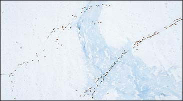
Setting off the next morning with Robert, Alex, and Subhankar, I climbed the steep tundra slope behind the camp, my eyes at the level of a sunshined bed of fresh blue lupines and translucent yellow poppies. From the plateau, Robert pointed at the low hills across the river where this coastal plain, including the 1002, has the highest density of land-denning female bears on the Arctic coast.
We went south along the escarpment, scanning the willow bottoms of the riverbed for grizzlies and musk ox. A golden eagle flapped downriver, far below, and a gyrfalcon passed rapidly overhead. Against the background of rock towers and the Brooks Range, the highland plateau was mysterious and beautiful, its wildflower meadows broken here and there by lonely monoliths like leaning headstones.
Where the caribou herds descend into the willow bottoms to ford the river, we followed their tracks to the foot of the escarpment, then continued southward. (At this time, the herds with their new young had already returned into the mountains; some will arrive in the Gwich’in country by late summer.) Up the valley, the rock towers seemed to brace the steep, grassy inclines. At the gyrfalcon aerie, under a rock ledge high above, two big gray chicks were still hunched on the nest, and a half-fledged sibling flapped and flopped on the rocks below. From a craggy outcrop overlooking the Kongakut Valley, the adult bird, a gray gyrfalcon, screeched a brief warning but otherwise sat motionless as stone, its yellow talons gleaming in the sun. On the next turret was the crude nest of the big rough-legged hawk that commanded the rock above, and from one of the towers came the scream of peregrines. One darted out high over the valley and cut back at once toward its hidden nest. To have observed the rough-leg, golden eagle, peregrine, and gyrfalcon within one hour on the same escarpment—astonishing!
Returning to camp, Alex and Subhankar walked the upland tussock to avoid mosquitoes, while Robert and I chose the easier going of the willow bottoms. In the maze of big-deer prints—moose and caribou—we looked for sign of musk ox and found wolf instead. Noting fresh bear scat along our way, I was content that my companion wore a holstered .45 Long Colt six-shooter on his belt that dragged his pants down as he rolled through the thickets.
LEAVING THE LAST FOOTHILLS behind, the Kongakut River descended into the flat coastal plain of the Barren Ground, where we hoped to cross Siku Lagoon to the barrier island known as Icy Reef. Having cleansed itself of the storm roil of a few days ago, the water was clear jade over the stones, fresh turquoise in the channels. In the brilliant air, the whites of the passing birds brightened the green-gray monotones of the tundra. Soon the current passed through overflow ice, up to six feet high on both banks of the channel, deepening the chill of a hard northeast wind that slowed the heavy round-bowed boats. The ice wall was broken here and there by eroded banks over ice-filled stony earth, presenting a grisly and primordial appearance, as if a mammoth tusk might protrude at any moment. On a high bank over a river bend sat a small statue of white ice, which from a distance looked like a melted snowman, but the snowman’s head revealed a yellow eye—a snowy owl, which in the next instant flopped down and away over the channel. Leaving the delta, the bottom changed to the gray, clay mud of the brackish lagoon. Warmed by the endless sunlight, the lagoon was full of nutrients, supporting great numbers of waterfowl and shorebirds, but on this tide it was too shallow to float the boats; finally we dragged them a half-mile across the lagoon to a likely campsite out on Icy Reef, a narrow gravel spit perhaps 60 yards across and four feet above sea level that separates the lagoon from the drift ice and the Arctic Ocean. Crowding the reef’s outer beach, the sculpted forms of stranded icebergs extended offshore a half-mile, reflecting like floating sculptures in the still, black water, which was broken now and then by the dark, skinny head of a ringed seal. We had four days to explore this region before the planes came to pick us up.
Taking a kayak on the second day, I set out across the glassy stillness. Long-tailed duck, eider, and loon pitched in nearby, making a soft, whispering rush as they subsided into the mirror. Where the sea had broken through the barrier island, a large, grayish seal—the bearded seal—parted the surface and slid beneath again, but another was so taken aback by our sudden confrontation that it whirled in a great thrash as it disappeared.
I drifted for a long time in the light of endless day. Off to the south, beyond the plain, rose the steep ramparts of the northernmost mountains of the New World. Off to the west, thin wisps of sunlit rain drifted over the 1002. Across the water, on a low cliff where the barren ground touches the sea, walked the misted silhouettes of caribou, and near the caribou a pair of sandhill cranes. On the beach crest, upright and heraldic on a silver limb, a magnificent peregrine, gray-blue above and lightly barred ivory on the breast and belly, watched the half-man in the gliding craft without the smallest twitch of wing.
That night was spent on the tundra across the lagoon, near an old hunting and fishing camp with an ancient log cabin, a small graveyard, and some grassy platforms where tents were erected and large hides pegged out to be scraped and dried. The Inupiat hunters come here less often now, according to Robert Thompson, who told me that his Inupiat people, accustomed to motor snowsleds and outboard boats, rarely need to camp so far from home. In the quarter-century since the first oil left the Arctic slope in the trans-Alaska pipeline, the dogsled and the dogs themselves have largely vanished.
AT 9 A.M. ON JULY 23, when Kirk Sweetsir landed his Cessna on the gravel crest of Icy Reef, the day was clear. I flew out with Robert and Subhankar over the 1002. The coastal tundra was dotted by a hundred pairs of tundra swans, and two cow moose with well-grown calves were perhaps a mile apart, throwing big black shadows in the morning light. Across the Aichilik delta, the olive monotones and grassy ponds were indistinguishable from the Kongakut tundra except that as the plane flew west, the coastal plain widened and the mountains receded into the mists. The caribou concentrate in the 1002 because the greater distance from the mountains cuts down predation on new calves by the grizzlies and wolves. Also, the hard winds across the barren spare the tight-pressed herds the worst of the mosquito hordes and biting flies. On the myriad trails that web the odd polygonal tundra surface, a lone caribou plodded inland, head low under its great antlers. As we flew over the Jago River, Kirk spotted musk ox tracks under a bank. The plane crossed the northern 1002, then a broad, open bay, before landing at Robert’s village of Kaktovik, on Barter Island (so called because Inupiat bands up and down the coast used to meet here to trade). A traditional fishing place—Kaktovik means “Seining Place”—with a large pond of good fresh water on the high ground, the site has been occupied for thousands of years, said Robert, but it wasn’t until a Distant Early Warning site (part of the array of missile-detection sites spread across the top of North America during the Cold War) was built on the high ground behind the village back in the 1950s that the outlying Inupiat were relocated to benefit from new jobs and a new clinic and school. The village is now made up of about 280 people.
Arriving at his small blue house, Robert seemed vaguely astonished by the gear that overflows his yard—heaped fishnets, a kayak, oil cans, boots, an abandoned dogsled, and some long black strips of baleen from the great jaws of a bowhead whale (Kaktovik is allowed a quota of three whales each year).
We were joined at breakfast by his wife, Jane Thompson, born Jane Akootchook and raised here in Kaktovik. “Our people never had no rights from the very start,” she said. “Who gave the Russians the right to own Alaska or sell it to the Americans? Sold my people to America right along with it. When the Air Force came here in 1947, all our coast people got moved to Kaktovik. We never had no say about it, even though this coast plain out here is our land, not theirs. And our people were put here to take care of it,” she continued, referring to the 92,000 acres of subsurface rights in the 1002 given to the people of Kaktovik as a result of the 1971 Alaska Native Claims Settlement Act. The Settlement Act led to the establishment of the North Slope Borough, a group of locally elected officials which governs Kaktovik and the seven other settlements on the North Slope. The borough taxes oil companies for land use and allocates the revenues for civic improvements, such as better schools and sewage systems. (The state government in Juneau receives royalties from oil companies, which are then dispersed to Alaskan citizens—last year, almost $2,000 per person.)
The Inupiat supported the Gwich’in against oil development as late as 1979, enjoining the federal government to award permanent protection to the calving area. But the improvements that swept in with oil money changed the mood in Kaktovik, and the majority of the Inupiat now support drilling in the 1002. Yet they still oppose any offshore drilling, since the sea and its creatures are sacred to their life in the way that the caribou are sacred to the Gwich’in. “Our people accepted development because they have always been so poor, and they are unhappy when people say they are just greedy,” Robert said. “This is their chance to improve their standard of living, maybe own some of the things they see on the TV—well, you can’t blame ’em.”
A LARGER PLANE FLEW THE EXPEDITION across the western section of the 1002 to the oil fields at Prudhoe Bay. By the time it left Kaktovik in late afternoon, the coast weather had turned colder, the sky was dark, with gusts and light rain, and a heavy sea fog swept like smoke across the Inupiat land. Some 60 miles west, near the Canning River, which separates the 1002 from the oil fields, we spotted perhaps 200 caribou wandering the plain, with another band of 30 or 40 not far away. These animals west of the 1002 belong to the so-called Central Arctic herd.
Soon the first drilling pad took shape in the blowing fog, its 12 ghostly wells lined up in two neat rows. Behind the well pumps were several huge rectangular reserve pits for the fluids used for cooling and lubrication. Thirty years of oil-field operations have produced millions of tons of “drilling muds,” which nobody had figured out how to get rid of.
Beyond the first wells, roads and land scars gouged by tracked vehicles began accumulating. More drilling pads loomed dimly through the fog, which mercifully shrouds the wastelands of one of the earth’s largest industrial sites; in the North Slope’s oil fields, there are almost 4,000 wells, 500 miles of gravel roads, and 12 enormous flow stations that separate the oil from gas and water. The infrastructure is made all the more intrusive by airstrip construction, production facilities, sewage plants, and housing for workers.
For a time, Prudhoe’s deposits of high-quality crude oil, readily “recovered” from permeable rock, were immensely profitable, delivering at their peak as many as two million barrels a day. But according to the Natural Resources Defense Council, the extraction of oil and the resulting industrial burden on the North Slope also produced an annual toxic load of 56,000 tons of nitrogen oxides, some 24,000 to 114,000 metric tons of methane, and up to 11 metric tons of carbon dioxide, the chief component in the greenhouse gases implicated in global warming. The oil fields and pipeline still average about one spill daily; there were 1,600 recorded spills from 1996 to 1999 alone.
In support of its claim that future drilling in the 1002 will affect only a small area of the Arctic National Wildlife Refuge, the oil industry promises more precise mapping of deposits, horizontal drilling from smaller pads up to four miles away, and other new technology that it claims will reduce the size of its “footprint” on the tundra. The oil companies claim the damage might also be offset by limiting exploration to the winter months and using ice roads instead of digging gravel. But even if all this should work, to drill a new oil field efficiently would still require an estimated 280 miles of new roads and hundreds of miles of new pipelines. Realistic predictions of economically recoverable oil in the 1002, based on U.S. Geological Survey studies in 1998, work out to about 3.2 billion barrels (assuming a price of $20 a barrel), or less than a six-month supply for America’s wasteful fossil fuel economy, which consumes 25 percent of the world’s oil production while possessing only 3 percent of its known reserves. Drilling in the 1002 is no quick fix, for even if drilling is approved, most energy companies estimate that no oil would be ready for consumption for at least a decade. The Environmental Protection Agency has determined that if manufacturers increased the fuel efficiency of cars and trucks by just three miles per gallon, we would save more than a million barrels of oil a day—five times what the refuge could possibly supply—thus reducing the dread dependence on foreign oil far faster than the proposed drilling in our last great expanse of pristine land.
In any case, the westbound caribou, put off by the scaring din and reek in their home territory, would probably stop short of the 1002 and calve farther to the east, producing fewer young and altering the migration patterns on which the Gwich’in villages and the whole ecosystem depend. And this disruption of a fragile wilderness would almost certainly lead to widespread ecological degradation.
LEAVING THE AIRSTRIP AT DEADHORSE, south of Prudhoe Bay, the pilot followed the silver tube of the trans-Alaska pipeline and the service route known as the Haul Road. To the west lay Service City, a defunct camp where the oil gave out in 1986. Service City and the Sacred Place Where Life Begins: The names tell us more than we might care to confront about our culture’s increasing alienation from what native peoples know as Land and Life.
Ten days earlier, in Arctic Village, I had listened happily to Trimble Gilbert, a tall elder with thick glasses and a big smile in a mouth with few front teeth, and a former village chief who serves as spiritual leader. In Gwich’in mythology and creation stories, Mr. Gilbert said, Caribou has a piece of Man’s heart in its heart, and a piece of Caribou’s heart rests in the heart of Man, so that each will always know what the other is doing. “Those elders who followed the traditional way knew a lot about animals,” he continued, “and they would know when our caribou were coming. They would dream that they would be here in a few days. Many caribou used to cross our river—not anymore. In the last 20, 30 years since the pipeline came along, things have changed. The birds don’t come. We don’t hear their singing. When I was growing up, I couldn’t wait till spring, to see them, hear them! Every spring! Not anymore. If we don’t stop this oil development, everything will go. It might take 20 or 30 more years, then everything will be gone.
“I don’t want to lose our animals. Those little birds [phalaropes] that go round and round on the water, every pond: I haven’t seen one in 20 years. And swallows! You’d see them all over, whirling up and down—it’s fun! Now, my wife, Mary, she says, ‘Where did the swallows go?'” He paused. “That is something taken from our lives that we can’t put back.
“We try to keep our community together. That is our Indian power. That is our way,” Mr. Gilbert said, smiling his great toothless smile. “I see my father’s fishing place, my grandfather’s camp, then I am at peace again. We respect our land, and the refuge is our land. This is our home.”
This article was adapted from an essay by PETER MATTHIESEN in Arctic National Wildlife Refuge: Seasons of Life and Land (The Mountaineers Books), to be published in March.